Filter: Categories of Wisconsin Historical Images
Filter: Subject of Suburbs
Filter: Subject of cities and towns
Filter: Subject of land
Filter: Categories of Wisconsin Historical Images
Filter: Subject of Suburbs
Filter: Subject of cities and towns
Filter: Subject of land
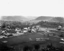
| Date: | 1940 |
|---|---|
| Description: | Elevated view over trees of village. In the background is a water tower on a hill with trees. |

| Date: | 04 21 1948 |
|---|---|
| Description: | Aerial photograph of the west side of Madison and the western edge of Lake Mendota. Taken over the west side of Madison looking northwest toward Middleton. |
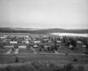
| Date: | 07 24 1966 |
|---|---|
| Description: | Elevated view of small town. A Lake Wisconsin is visible beyond the town limits. |

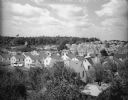
| Date: | 02 02 1978 |
|---|---|
| Description: | "The camera looks to the new subdivision and beyond." |

| Date: | 1950 |
|---|---|
| Description: | This map is accompanied by booklet: "Know Milwaukee Map and Street Guide". The map is a detailed map of Milwaukee and the surrounding suburbs. Streets and ... |
| Date: | 12 23 1949 |
|---|---|
| Description: | Typed and printed ink on paper. Map lists and shows suburbs in 1940. Map reads: "Milwaukee Metropolitan district in 1940. Pub. in Bayrd Still’s Milwaukee, ... |

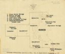
| Date: | 1903 |
|---|---|
| Description: | Shows lot numbers and dimensions. "Issued May 31, 1903" -- Inscribed in ink. Oriented with north to the upper right. Includes text. Labelled streets are "R... |

| Date: | 04 04 1934 |
|---|---|
| Description: | Street map of the city of Milwaukee and surrounding communities at a scale of 1 inch to 1200 feet. |

| Date: | 1965 |
|---|---|
| Description: | This map shows landownership, acreages, and roads. The city of De Pere, the town of Hobart, and the Fox River are labeled. Inset maps showing Smits Subdivi... |

| Date: | 1908 |
|---|---|
| Description: | A Sanborn map of the isthmus, which includes the map key. |
If you didn't find the material you searched for, our Library Reference Staff can help.
Call our reference desk at 608-264-6535 or email us at: