Filter: Categories of Wisconsin Historical Images
Filter: Subject of Suburbs
Filter: Subject of cities and towns
Filter: Categories of Wisconsin Historical Images
Filter: Subject of Suburbs
Filter: Subject of cities and towns
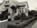
| Date: | 1924 |
|---|---|
| Description: | View from across street of the landscaping of a suburban home. Original title reads: "Good foundation plantings. Desirable open lawn evergreens may eventua... |
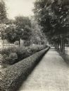
| Date: | 1924 |
|---|---|
| Description: | Group planting of a low hedge line along tree-lined sidewalk in suburban area. The original caption identifies it as "well-executed." |
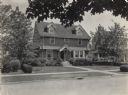
| Date: | 06 1931 |
|---|---|
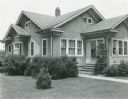
| Description: | Front yard landscaping of house in a residential neighborhood. Original caption reads: "Home of Mock Jr., 15 S. Commonwealth Ave., 2nd prize winner in 'Tri... |
| Date: | 06 1931 |
|---|---|
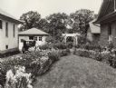
| Description: | Home garden in a residential neighborhood. Landscaping includes iris and peonies in borders along a driveway, and an arched trellis near the backyard. Orig... |
| Date: | 06 1926 |
|---|---|
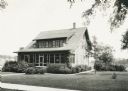
| Description: | Front yard with shrubs and evergreens around foundation of suburban house. |
| Date: | 06 1931 |
|---|---|
| Description: | Front yard landscaping for the house of Harold Rahow, 712 N. Grove Avenue, including shrubbery and trees. |

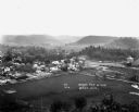
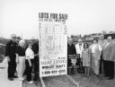
| Date: | 09 13 1952 |
|---|---|
| Description: | View of the first of the thousands of people who toured the 18 new homes erected by 15 builders at Nakoma Road and the West Beltline. The Parade of Homes w... |
| Date: | 02 02 1978 |
|---|---|
| Description: | "The camera looks to the new subdivision and beyond." |
| Date: | 03 1998 |
|---|---|
| Description: | "Village officials help kick off Valley Estates Subdivision." |
| Date: | 03 1998 |
|---|---|
| Description: | "Progress on Valley Estates Subdivision." |

| Date: | 1950 |
|---|---|
| Description: | This map is accompanied by booklet: "Know Milwaukee Map and Street Guide". The map is a detailed map of Milwaukee and the surrounding suburbs. Streets and ... |
| Date: | 12 23 1949 |
|---|---|
| Description: | Typed and printed ink on paper. Map lists and shows suburbs in 1940. Map reads: "Milwaukee Metropolitan district in 1940. Pub. in Bayrd Still’s Milwaukee, ... |

| Date: | 1903 |
|---|---|
| Description: | Shows lot numbers and dimensions. "Issued May 31, 1903" -- Inscribed in ink. Oriented with north to the upper right. Includes text. Labelled streets are "R... |
| Date: | 03 03 1937 |
|---|---|
| Description: | A pencil drawing of a proposed area of the planned community of Greendale, Wisconsin. The community was established as an objective of the Department of Ag... |
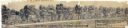
| Date: | 1960 |
|---|---|
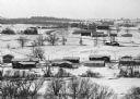
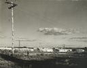
| Description: | New residential construction on the outer southwest edge of Madison. |

| Date: | 04 04 1934 |
|---|---|
| Description: | Street map of the city of Milwaukee and surrounding communities at a scale of 1 inch to 1200 feet. |
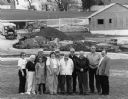
| Date: | 02 23 1960 |
|---|---|
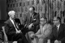
| Description: | Once a year, members of the Shorewood Hills village board and members of the Blackhawk Country Club board of directors get together for a social evening to... |

| Date: | 1966 |
|---|---|
| Description: | This map shows streets, highways, railroads, parks, colleges, cemeteries, county clubs, University of Wisconsin, Truax Field, Middleton, Shorewood Hills, M... |

| Date: | 1969 |
|---|---|
| Description: | This map is pen and ink on paper and shows the location of churches, local streets, railroads, parks, Middleton, Shorewood Hills, Monona, Maple Bluff, McFa... |
If you didn't find the material you searched for, our Library Reference Staff can help.
Call our reference desk at 608-264-6535 or email us at: