 Filter: Categories of Wisconsin Historical Images
Filter: Subject of Surveying
Filter: Subject of transportation
Filter: Categories of Wisconsin Historical Images
Filter: Subject of Surveying
Filter: Subject of transportation

| Date: | 1850 |
|---|---|
| Description: | This series of maps shows townships, ranges, sections, lakes, rivers, and roads. The maps cover areas between Township No. 26 and Township No. 42. |

| Date: | 1919 |
|---|---|
| Description: | Surveyor's drawings of William Deerings Agricultural Works in Lake View, Illinois erected in 1880. |
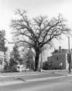
| Date: | 1981 |
|---|---|
| Description: | View across street towards a very tall bur oak towering over nearby houses at the corner of Main and Franklin Streets. There is a small monument at its bas... |

| Date: | 1955 |
|---|---|
| Description: | A large, spreading bur oak standing directly in the intersection of Hammond and Hanerville Roads, both unpaved. There is a row of smaller trees lining Hane... |

| Date: | 1880 |
|---|---|
| Description: | A map of Milwaukee which includes a city street guide. |
If you didn't find the material you searched for, our Library Reference Staff can help.
Call our reference desk at 608-264-6535 or email us at: