 Filter: Categories of Wisconsin Historical Images
Filter: Subject of Surveying
Filter: Year of 1900-1999
Filter: Creator Name of Unknown
Filter: Categories of Wisconsin Historical Images
Filter: Subject of Surveying
Filter: Year of 1900-1999
Filter: Creator Name of Unknown
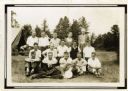
| Date: | 1932 |
|---|---|
| Description: | Group portrait of a group of Wisconsin Land Economic Inventory workers. John Bordner is in the center of the top row. Stanta Bordner is beside him. Uppe... |
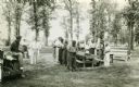
| Date: | 1937 |
|---|---|
| Description: | Probably Native Americans receiving instructions on compass use for Wisconsin Land Economic Inventory. |
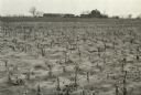
| Date: | 04 23 1937 |
|---|---|
| Description: | Sand barrens being used for poor crops. Note on back of print reads: "This should be in timber." |

| Date: | 04 1937 |
|---|---|
| Description: | From back of print: "Dane County, Town of Middleton, north 1/2 section of section 17 looking SW from a hill across the valley showing erosion and stump pas... |

| Date: | 1920 |
|---|---|
| Description: | This map identifies the areas of the state that had been geologically surveyed or topographically surveyed, or both, as well as portions of the state still... |

| Date: | 1923 |
|---|---|
| Description: | This topographical map of Devil's Lake State Park, Sauk County, Wisconsin, is based on 1922-1923 surveys of the area by the University of Wisconsin Summer ... |
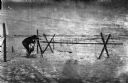
| Date: | 1918 |
|---|---|
| Description: | Outdoor view of a U.S. Army Engineer topographer wearing skis while in the process of surveying land. The engineer is standing next to a barbed wire obstac... |

| Date: | 1918 |
|---|---|
| Description: | Outdoor view of a U.S. Army Engineer topographer wearing skis while using a tripod stand to write. The engineer is standing next to a barbed wire obstacle ... |
If you didn't find the material you searched for, our Library Reference Staff can help.
Call our reference desk at 608-264-6535 or email us at: