 Filter: Categories of Wisconsin Historical Images
Filter: Subject of Surveying
Filter: Year of 1900-1999
Filter: Subject of cities and towns
Filter: Categories of Wisconsin Historical Images
Filter: Subject of Surveying
Filter: Year of 1900-1999
Filter: Subject of cities and towns

| Date: | 1969 |
|---|---|
| Description: | A surveyor conducts work at the construction of the World Trade Center. He is at work before the building located at 210 Washington Street. |

| Date: | 04 1937 |
|---|---|
| Description: | From back of print: "Dane County, Town of Middleton, north 1/2 section of section 17 looking SW from a hill across the valley showing erosion and stump pas... |
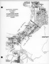
| Date: | 03 16 1950 |
|---|---|
| Description: | Map of areas surveyed by block number as part of the Madison Housing Authority Survey of Substandard Housing. |
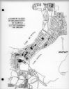
| Date: | 03 16 1950 |
|---|---|
| Description: | Map of locations by block of dwellings rated as blighted as part of the Madison Housing Authority Survey of Substandard Housing. |
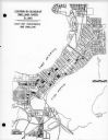
| Date: | 03 16 1950 |
|---|---|
| Description: | Map of locations of blocks of dwellings rated as slums, as part of the Madison Housing Authority Survey of Substandard Housing. |
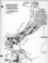
| Date: | 03 16 1950 |
|---|---|
| Description: | Map of locations by blocks or areas of dwelling units in which violations of ordinance were apparent as part of the Madison Housing Authority Survey of Sub... |

| Date: | 03 16 1950 |
|---|---|
| Description: | A chart showing distribution of 1,148 substandard dwelling units found in the survey area, by basic type of fault, as part of the Madison Housing Authority... |

| Date: | 1956 |
|---|---|
| Description: | A map depicting the for systems of land description in Wisconsin, which include metes and bounds, U.S. System of Rectangular Surveys, Latitude and longitud... |

| Date: | 1918 |
|---|---|
| Description: | Outdoor view of a U.S. Army Engineer topographer wearing skis while using a tripod stand to write. The engineer is standing next to a barbed wire obstacle ... |

| Date: | 02 02 1960 |
|---|---|
| Description: | The Madison Redevelopment Authority joined in the city's program of locating and permanently marking land survey corners in the Madison area. Here they mar... |

| Date: | 1903 |
|---|---|
| Description: | This map shows lakes, rivers, railroads, and the soil types of towns and counties. A legend of soil types and conventional signs is included. Relief is sho... |

| Date: | 1975 |
|---|---|
| Description: | This map provides an index of quadrangle maps for the state. The lower left corner contains explanation land surveying completeness. Communities, counties,... |

| Date: | 1975 |
|---|---|
| Description: | This map provides an index of outdated quadrangle maps for the state. Communities, counties, rivers, and lakes are labeled including Lake Michigan and Lake... |
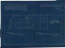
| Date: | 11 1925 |
|---|---|
| Description: | This blueprint manuscript map shows an addition. The map was surveyed and platted for B.G. Proctor, president, and George Peterson, secretary, of the Corne... |

| Date: | 04 11 1940 |
|---|---|
| Description: | This blue line print map shows survey monument markers by type and industrial buildings and covers part of the lower Fox River and East River. The map incl... |

| Date: | 1950 |
|---|---|
| Description: | This photocopy of a manuscript map shows sectional township grid, hydrography, and acreages as they appeared in 1836. The township lines surveyed by Mullet... |

| Date: | 1919 |
|---|---|
| Description: | Surveyor's drawings of William Deerings Agricultural Works in Lake View, Illinois erected in 1880. |
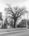
| Date: | 1981 |
|---|---|
| Description: | View across street towards a very tall bur oak towering over nearby houses at the corner of Main and Franklin Streets. There is a small monument at its bas... |
If you didn't find the material you searched for, our Library Reference Staff can help.
Call our reference desk at 608-264-6535 or email us at: