 Filter: Categories of Wisconsin Historical Images
Filter: Subject of Surveying
Filter: Year of 1900-1999
Filter: Year of 1950-1959
Filter: Categories of Wisconsin Historical Images
Filter: Subject of Surveying
Filter: Year of 1900-1999
Filter: Year of 1950-1959
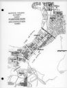
| Date: | 03 16 1950 |
|---|---|
| Description: | Map of areas surveyed by block number as part of the Madison Housing Authority Survey of Substandard Housing. |
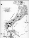
| Date: | 03 16 1950 |
|---|---|
| Description: | Map of locations by block of dwellings rated as blighted as part of the Madison Housing Authority Survey of Substandard Housing. |
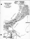
| Date: | 03 16 1950 |
|---|---|
| Description: | Map of locations of blocks of dwellings rated as slums, as part of the Madison Housing Authority Survey of Substandard Housing. |
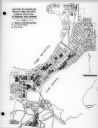
| Date: | 03 16 1950 |
|---|---|
| Description: | Map of locations by blocks or areas of dwelling units in which violations of ordinance were apparent as part of the Madison Housing Authority Survey of Sub... |

| Date: | 03 16 1950 |
|---|---|
| Description: | A chart showing distribution of 1,148 substandard dwelling units found in the survey area, by basic type of fault, as part of the Madison Housing Authority... |

| Date: | 1956 |
|---|---|
| Description: | A map depicting the for systems of land description in Wisconsin, which include metes and bounds, U.S. System of Rectangular Surveys, Latitude and longitud... |

| Date: | 03 09 1955 |
|---|---|
| Description: | A man wearing a hat looks through the eye piece of his surveying instrument, called a 'theodolite,' which rests on a tripod. |

| Date: | 07 14 1958 |
|---|---|
| Description: | This is a Tellurometer, a microwave surveying instrument. The operator is Don Reed, field man for Alster and Associates, Washington, D.C., which completed ... |

| Date: | 1950 |
|---|---|
| Description: | This photocopy of a manuscript map shows sectional township grid, hydrography, and acreages as they appeared in 1836. The township lines surveyed by Mullet... |

| Date: | 1955 |
|---|---|
| Description: | A large, spreading bur oak standing directly in the intersection of Hammond and Hanerville Roads, both unpaved. There is a row of smaller trees lining Hane... |
If you didn't find the material you searched for, our Library Reference Staff can help.
Call our reference desk at 608-264-6535 or email us at: