 Filter: Categories of Wisconsin Historical Images
Filter: Subject of Taverns (Inns)
Filter: Subject of education
Filter: Categories of Wisconsin Historical Images
Filter: Subject of Taverns (Inns)
Filter: Subject of education

| Date: | 1910 |
|---|---|
| Description: | Chippewa Falls from the south side of the river below the falls. Includes the Sheely House Tavern, railway buildings, box cars, a train with five passenger... |
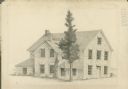
| Date: | 1946 |
|---|---|
| Description: | Pencil drawing of a stone building in Cross Plains, which used to house a tavern downstairs and the town's school upstairs. Features a porch entrance, and ... |

| Date: | 1870 |
|---|---|
| Description: | This 1870 map of Brown County, Wisconsin, shows the township and range grid, towns, sections, cities, villages and post offices, land ownership, roads, rai... |

| Date: | 02 17 1961 |
|---|---|
| Description: | Secretary of State Robert Zimmerman, kneeling, presides at the cornerstone laying ceremony for the new Madison Inn, located at Frances and Langdon Streets.... |

| Date: | 06 12 1929 |
|---|---|
| Description: | This manuscript blueprint shows buildings with the names of their owners, tabernacle, location "where Strang found plates" and "house where Strang died," a... |
If you didn't find the material you searched for, our Library Reference Staff can help.
Call our reference desk at 608-264-6535 or email us at: