 Filter: Categories of Wisconsin Historical Images
Filter: Subject of Taverns (Inns)
Filter: Subject of postal service
Filter: Categories of Wisconsin Historical Images
Filter: Subject of Taverns (Inns)
Filter: Subject of postal service

| Date: | 1950 |
|---|---|
| Description: | Caption reads: "Looking West on Main Ave." View down center of commercial area, with automobiles moving down the street, and parked along the curbs. A U.S.... |

| Date: | 1930 |
|---|---|
| Description: | View up Main Street, with houses up on a hill on the left above a stone wall that runs along the sidewalk. On the right is a sign that reads: "Maiden R[ock... |
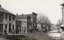
| Date: | 1906 |
|---|---|
| Description: | View down unpaved street with snow along the curbs. The Post office is the first building on the left. Other buildings are occupied by a doctor's office, s... |
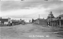
| Date: | 1937 |
|---|---|
| Description: | View looking down middle of Main Street. Businesses from left to right include the U.S. Post Office, Tire & Battery Service, Store - Tourist & Supplies, St... |

| Date: | 1858 |
|---|---|
| Description: | An ink on paper map of Milwaukee County and the eastern portion of Waukesha County that shows the townships of Oak Creek, Franklin, Greenfield, Wauwatosa, ... |

| Date: | 1870 |
|---|---|
| Description: | This 1870 map of Brown County, Wisconsin, shows the township and range grid, towns, sections, cities, villages and post offices, land ownership, roads, rai... |
If you didn't find the material you searched for, our Library Reference Staff can help.
Call our reference desk at 608-264-6535 or email us at: