 Filter: Categories of Wisconsin Historical Images
Filter: Subject of Tourism
Filter: Reproduction Rights of For Sale
Filter: County of Door
Filter: Categories of Wisconsin Historical Images
Filter: Subject of Tourism
Filter: Reproduction Rights of For Sale
Filter: County of Door
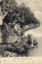
| Date: | 1906 |
|---|---|
| Description: | View of Lover's Leap with a group of people on the rocks near the shoreline under an overhang. Caption reads: "Lovers Leap, Sturgeon Bay, Wis." |

| Date: | 1954 |
|---|---|
| Description: | View looking west from Eagle Bluff toward Nicolet Bay, the Strawberry Islands, and Chambers Island. Three people are sitting on the stone wall of the overl... |

| Date: | 1941 |
|---|---|
| Description: | This 1941 tourist map of Washington Island, Wisconsin, shows points of interest and places of business. Some information is shown pictorially. Rock, Hog, D... |

| Date: | 1938 |
|---|---|
| Description: | This tourist map of Door County, Wisconsin, lists the points of interest and resorts in the area. An inset location map is included. |

| Date: | 1940 |
|---|---|
| Description: | This tourist map of Door County, Wisconsin, lists the points of interest and tourist hotels, cabins and cottages in the area. Ferry schedules to Washington... |

| Date: | 1930 |
|---|---|
| Description: | "Issued by Door County Chamber of Commerce." Shows federal system highways, state highways, county trunk highways, country roads, and parks. Includes direc... |

| Date: | 1966 |
|---|---|
| Description: | A colored map depiction of Door County, Wisconsin, with pictorial highlights, titled: "Door County — Wisconsin's Air Conditioned Peninsula Playground." |
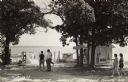
| Date: | 1940 |
|---|---|
| Description: | Photographic postcard view looking out at people standing, and some fishing, on the Northport pier at Death's Door, with the bay in the background. |
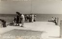
| Date: | 1940 |
|---|---|
| Description: | Black and white photographic postcard of people on the shoreline and on the pier at Death's Door. Signs on a tree near a snack stand on the right read: "Sm... |

| Date: | 1960 |
|---|---|
| Description: | View across water towards a man, woman, and two children standing on the rock ledge at Cave Point. Lake Michigan is on the right. |
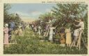
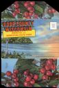
| Date: | 1920 |
|---|---|
| Description: | Colorized postcard view of tourists picking cherries. |
| Date: | 1920 |
|---|---|
| Description: | Envelope cover. Inside are eighteen color enhanced photographic scenes from Door County, Wisconsin, including a short description of Door County features t... |

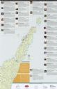
| Date: | 1960 |
|---|---|
| Description: | This map shows public boat ramps, parks, highways, beaches, bluffs, Green Bay, Garrett Bay, Europe Bay and Lake, Rowley's Bay and Ellison Bay. The map incl... |

| Date: | 1970 |
|---|---|
| Description: | This map shows roads, parks, swimming beaches, golf courses, yacht harbors, light houses, airports, public hunting grounds, waysides, schools, and fishing ... |
| Date: | 2012 |
|---|---|
| Description: | This map includes a descriptive index of galleries and studios with color illustrations, on both sides. |
| Date: | 1963 |
|---|---|
| Description: | Text on reverse reads: "Vacationland Farm, Hwy. 57, S. Sister Bay, Wis. 54234. Farm Petting Zoo * Riding Stables * Pony Ring Game Room * Gift Shop. Excelle... |

| Date: | 1950 |
|---|---|
| Description: | Text on reverse reads: "Land of Make Believe in the Center of Door County. Unique Museum. Largest Collection Anywhere. Old Marshall Field Window Mechanical... |

| Date: | 1950 |
|---|---|
| Description: | Text on reverse reads: "Land of Make Believe in the Center of Door County. Unique Museum. Largest Collection Anywhere. Old Marshall Field Window Mechanical... |
If you didn't find the material you searched for, our Library Reference Staff can help.
Call our reference desk at 608-264-6535 or email us at: