 Filter: Categories of Wisconsin Historical Images
Filter: Subject of Trails
Filter: Community of Madison
Filter: Year of 1800-1899
Filter: Categories of Wisconsin Historical Images
Filter: Subject of Trails
Filter: Community of Madison
Filter: Year of 1800-1899
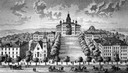
| Date: | 1885 |
|---|---|
| Description: | A view of what is now known as Bascom Hill including Main Hall (Bascom Hall), North Hall, Music Hall, Science Hall, South Hall, Washburn Observatory and Wo... |
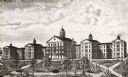
| Date: | 1889 |
|---|---|
| Description: | Wisconsin State Hospital for the Insane (Mendota Mental Health Institute) |

| Date: | 1890 |
|---|---|
| Description: | Cyanotype view from Bascom Hill of main entrance to Bascom Hall (formerly Main Hall) on the University of Wisconsin-Madison campus. |
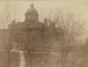
| Date: | 1893 |
|---|---|
| Description: | Elevated view from North Hall of main entrance to Bascom Hall (formerly Main Hall) on the University of Wisconsin-Madison campus. |
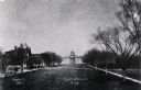
| Date: | 1880 |
|---|---|
| Description: | View up Bascom Hill on the University of Wisconsin-Madison campus. Bascom Hall (formerly Main Hall) is at the top of the hill. |
| Date: | 1895 |
|---|---|
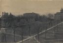
| Description: | Elavated view across Bascom Hill on the University of Wisconsin-Madison campus, with tree-lined paths. Bascom Hall (formerly Main Hall) is on top of the hi... |

| Date: | 11 24 1898 |
|---|---|
| Description: | Elevated view from the top of Main Hall (later Bascom Hall) of Picnic Point on Lake Mendota from the University of Wisconsin-Madison campus. |
| Date: | 1896 |
|---|---|
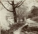
| Description: | Looking down University of Wisconsin Drive (present-day Lakeshore Path). Large trees grows along the shoreline on the left, and on the right is a thick woo... |

| Date: | 1896 |
|---|---|
| Description: | Mrs. Elsie Stevens poses on a path by a lake while riding a horse. Possibly on the University of Wisconsin-Madison drive (present-day Lakeshore path). |
| Date: | 1894 |
|---|---|
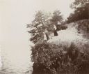
| Description: | Elevated view of three women and a young girl standing at the edge of a small cliff on the shores of Lake Mendota. Various shrubs and small trees grow on t... |

| Date: | 1836 |
|---|---|
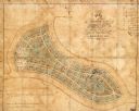
| Description: | Map shows rivers, creeks, roads, trails, mills, and town of Madison. Includes significant manuscript annotations; Sheet 1 is watercolor on lithographed map... |
| Date: | 1865 |
|---|---|
| Description: | This map of Forest Hill Cemetery is ink and watercolor on cloth. The upper right hand margin contains an index by name and lot. The bottom left corner read... |
If you didn't find the material you searched for, our Library Reference Staff can help.
Call our reference desk at 608-264-6535 or email us at: