 Filter: Categories of Wisconsin Historical Images
Filter: Subject of Trails
Filter: County of Ashland
Filter: Categories of Wisconsin Historical Images
Filter: Subject of Trails
Filter: County of Ashland
| Date: | |
|---|---|
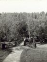
| Description: | Two people on a rustic bridge over Bad River at Copper Falls State Park. |

| Date: | 1938 |
|---|---|
| Description: | View of a house on Nebraska Row on Madeline Island. In the foreground is a flag pole, bench, path, lawn and trees. On the left are docks from the lake shor... |

| Date: | 1952 |
|---|---|
| Description: | This 1952 map shows the trails, roads, and railroads through the counties of Ashland, Bayfield, Sawyer, Price, Iron, and Vilas. Also shown are lakes, river... |

| Date: | 1925 |
|---|---|
| Description: | This 1925 map of Ashland County, Wisconsin, shows the township and range system, towns, sections, cities and villages, the Bad River Indian Reservation, ra... |
| Date: | 1913 |
|---|---|
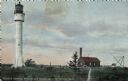
| Description: | Hand-colored postcard showing the lighthouse and fog signal at Devil's Island in the Apostle Islands. Caption reads: "Apostle Islands, Wis. Devil's Island,... |

| Date: | 1980 |
|---|---|
| Description: | This map shows the locations of 42 businesses, roads, points of interest, recreation sites, camping, the North Country Trail and parking, and boundaries of... |

| Date: | 1930 |
|---|---|
| Description: | A child is holding out a bowl to a pillar from which water is cascading down into a spring. In the background, two other children are walking up a dirt pat... |
If you didn't find the material you searched for, our Library Reference Staff can help.
Call our reference desk at 608-264-6535 or email us at: