 Filter: Categories of Wisconsin Historical Images
Filter: Subject of Trails
Filter: Subject of architecture
Filter: Year of 1800-1899
Filter: Categories of Wisconsin Historical Images
Filter: Subject of Trails
Filter: Subject of architecture
Filter: Year of 1800-1899
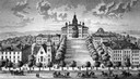
| Date: | 1885 |
|---|---|
| Description: | A view of what is now known as Bascom Hill including Main Hall (Bascom Hall), North Hall, Music Hall, Science Hall, South Hall, Washburn Observatory and Wo... |

| Date: | 1870 |
|---|---|
| Description: | A man is standing on the far left with a baby in a baby buggy, a boy on the far right is sitting on a rocking horse on the lawn, and a woman holding baby i... |

| Date: | 1890 |
|---|---|
| Description: | Cyanotype view from Bascom Hill of main entrance to Bascom Hall (formerly Main Hall) on the University of Wisconsin-Madison campus. |
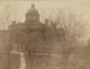
| Date: | 1893 |
|---|---|
| Description: | Elevated view from North Hall of main entrance to Bascom Hall (formerly Main Hall) on the University of Wisconsin-Madison campus. |
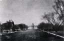
| Date: | 1880 |
|---|---|
| Description: | View up Bascom Hill on the University of Wisconsin-Madison campus. Bascom Hall (formerly Main Hall) is at the top of the hill. |
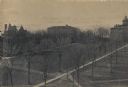
| Date: | 1895 |
|---|---|
| Description: | Elavated view across Bascom Hill on the University of Wisconsin-Madison campus, with tree-lined paths. Bascom Hall (formerly Main Hall) is on top of the hi... |
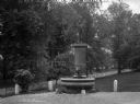
| Date: | 1895 |
|---|---|
| Description: | View of a statue and fountain in a grassy park depicting a boy selling a newspaper. Installed in 1895 and funded by Colonel William L. Brown, the statue c... |
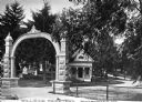
| Date: | 1870 |
|---|---|
| Description: | View of the gate and gatehouse at Hillside cemetery. Caption reads: "Hillside Cemetery, Whitewater, Wis." |

| Date: | 1899 |
|---|---|
| Description: | Topographical map showing ridges, water courses, boundary lines, and trails and roads near the Stanley McCormick's Riven Rock estate in El Montecito, Santa... |

| Date: | 1873 |
|---|---|
| Description: | This 1873 map of Chippewa County, Wisconsin, which at the time also encompassed all or part of Price, Rusk, Sawyer, and Taylor counties, shows the township... |

| Date: | 1800 |
|---|---|
| Description: | This map of the Little Kaukalin Region is ink on paper and shows Little Kaukalin Rapids, Black Bird Island, buildings, trails, meadows and woods, and a sug... |
If you didn't find the material you searched for, our Library Reference Staff can help.
Call our reference desk at 608-264-6535 or email us at: