Filter: Categories of Wisconsin Historical Images
Filter: Subject of Trails
Filter: Subject of transportation
Filter: Categories of Wisconsin Historical Images
Filter: Subject of Trails
Filter: Subject of transportation
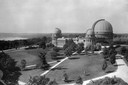
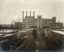
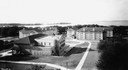
| Date: | 1935 |
|---|---|
| Description: | Elevated exterior view of Yerkes Observatory. Geneva Lake is in the background, left. Roads and sidewalks cross the sweeping, well tended lawns. The desi... |

| Date: | 1936 |
|---|---|
| Description: | This map is red and black ink on tracing cloth and is oriented with north to the upper left. This hand-drawn map shows a central portion of the military ro... |
| Date: | 05 1849 |
|---|---|
| Description: | Deserted Pawnee village in Nebraska. Sketched by Wilkins on his 151-day journey from Missouri to California on the Overland Trail (also known as the Oregon... |
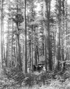
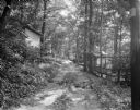
| Date: | 1905 |
|---|---|
| Description: | Trail through the pines between Chippewa Falls and Long Lake, Chippewa County. |
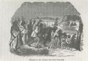
| Date: | |
|---|---|
| Description: | Photograph of an engraving from an unknown source depicting a group of Native American warriors herding white captives along a trail. A building burns in ... |
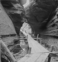
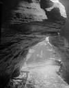
| Date: | |
|---|---|
| Description: | Looking out of the entrance to Witches' Gulch showing wooden walkway. |
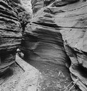
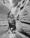
| Date: | |
|---|---|
| Description: | Fat Man's Misery, the narrow defile in Cold Water Canyon. |
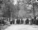
| Date: | |
|---|---|
| Description: | Unidentified group of tourists posing standing in Cold Water Canyon. There is a man in the background on the left with a camera. |
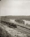
| Date: | |
|---|---|
| Description: | Elevated view of a train running parallel to the river, past the Ink Stand. Several people are standing along the tracks and waving. |
| Date: | 1924 |
|---|---|
| Description: | Two women standing on path in front of the Garver Feed Mill, which was originally a sugar beet processing factory. |

| Date: | 07 19 1933 |
|---|---|
| Description: | View along stone path leading to the side door of barn/carriage house at Ralph Warner's "The House Next Door," aka the Lovejoy-Duncan House, 11219 N. Webst... |
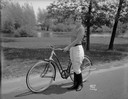
| Date: | 05 23 1933 |
|---|---|
| Description: | Janette Serrec, lecturer and writer on the "Fine Art of Successful Living," standing beside a Hawthorne bicycle from Ward's. She is wearing jodhpurs and bo... |
| Date: | 06 27 1931 |
|---|---|
| Description: | Path, "main street," through the woods at the University of Wisconsin Tent Colony. Also known as Camp Gallistella on the south shore of Lake Mendota, west ... |
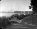
| Date: | 1926 |
|---|---|
| Description: | Lake Mendota, including Fraternity Row and east side shoreline, taken from the lake path on University Bay Drive. |
| Date: | 1926 |
|---|---|
| Description: | View of Adams, Tripp and Van Hise Halls. All are residence halls on the University of Wisconsin campus with Picnic Point and Lake Mendota in the backgroun... |
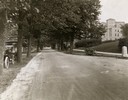
| Date: | 1922 |
|---|---|
| Description: | View of tree-lined Linden Drive includes parked motorcycles and automobiles on the University of Wisconsin campus. |
| Date: | 1912 |
|---|---|
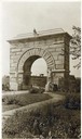
| Description: | Camp Randall Memorial Arch and Civil War cannons honor the Wisconsin Civil War soldiers on the University of Wisconsin-Madison campus. The memorial was nam... |
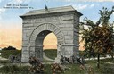
| Date: | 1912 |
|---|---|
| Description: | Camp Randall Memorial Arch and Civil War cannons. The memorial was built to honor Wisconsin Civil War soldiers and is located on the University of Wisconsi... |
If you didn't find the material you searched for, our Library Reference Staff can help.
Call our reference desk at 608-264-6535 or email us at: