 Filter: Categories of Wisconsin Historical Images
Filter: Subject of Trails
Filter: Year of 1900-1999
Filter: Creator Name of Unknown
Filter: Categories of Wisconsin Historical Images
Filter: Subject of Trails
Filter: Year of 1900-1999
Filter: Creator Name of Unknown
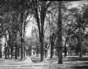
| Date: | 1910 |
|---|---|
| Description: | A view of the Oberlin College campus looking toward a campus building through trees. Caption reads: "Campus View, Oberlin, Ohio." |

| Date: | 1912 |
|---|---|
| Description: | Exterior of River Pine Sanitarium, which opened in 1906. A path surrounded by trees leads past benches to the sanitarium porch. Caption reads: "River Pine ... |

| Date: | 1907 |
|---|---|
| Description: | View of a straight gravel path through an informally planted garden. The side and roof of a building can be seen on the right. |

| Date: | 1907 |
|---|---|
| Description: | Backyard garden with a plank path bordered on one side by a wooden fence. A clothesline stretches across the yard from a fence post. |
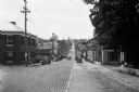
| Date: | 1930 |
|---|---|
| Description: | View down Midland Trail. Automobiles are parked on either side of the street outside an Amoco Station and other stores and dwellings. |

| Date: | 1991 |
|---|---|
| Description: | Mary Robinson, President of Ireland, escorting Speaker of the House of Representative Thomas Foley, who was heading a house leadership trip to Ireland. To ... |

| Date: | 1970 |
|---|---|
| Description: | A map showing highlighted snowmobile trails, ice crossings, and supporting businesses in the towns of Stephenson and Silver Cliff in Marinette County and ... |

| Date: | 1969 |
|---|---|
| Description: | A map of the Elroy-Sparta State Trail and the surrounding area, showing the townships, the towns of Cashton, Sparta, in the west, and Union Center and Elro... |

| Date: | 1975 |
|---|---|
| Description: | This 1975 road map of Columbia County, Wisconsin, shows the location of historic sites in the county but lacks a key to those sites. It includes an inset m... |

| Date: | 1970 |
|---|---|
| Description: | Map features a legend of roads, trails, points of interest, buildings, and types of vegetation. To the right are "ARBORETUM REGULATIONS" regarding hours, p... |

| Date: | 1974 |
|---|---|
| Description: | A map of Dane County from the Charles Brown Atlas. A hand-drawn blue line marks the Black Hawk Trail. |
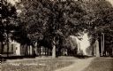
| Date: | 1911 |
|---|---|
| Description: | View along dirt path in a park. There is a soldier's monument in the background just beyond trees, and a brick building on the left. |

| Date: | 1992 |
|---|---|
| Description: | This guide features a map of suggested bike routes. Also included is a legend, text on how to use the map and legend, points of interest, and safety tips. |

| Date: | 1952 |
|---|---|
| Description: | This map shows roads, foot and canoe trails, railroads, resorts, lookout towers, camps, national and state forests, Indian reservation, and types of fish i... |

| Date: | 1900 |
|---|---|
| Description: | This map shows logging roads, railroads with spur lines, trails, rapids, lumber camps, Indian villages, summer resort, lakes, rivers, and ponds. |

| Date: | 1936 |
|---|---|
| Description: | This map shows campsites, trails, auto roads, surrounding townships, and points of interest, by including pictorial illustrations. Includes an inserted map... |

| Date: | 1975 |
|---|---|
| Description: | This map shows nature trails, public attractions, public hunting and fishing grounds, dams, waysides, lakes, highways, and roads. The upper right corner in... |

| Date: | 1966 |
|---|---|
| Description: | This map shows trails, roads, creeks, alleged location of George Gardner's trading post, Boulder and Mud Lakes, and a portion of the Wolf River. The map al... |
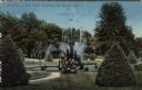
| Date: | 1911 |
|---|---|
| Description: | Hand-colored view of a fountain obscured by a flowering bush. Caption reads: "Fountain in Oak Grove Cemetery, La Crosse, Wis." |

| Date: | 1902 |
|---|---|
| Description: | A view across Lake Mendota from Tenney Park. A group of four children are on the near shoreline. A group of adults are standing and sitting in the midgroun... |
If you didn't find the material you searched for, our Library Reference Staff can help.
Call our reference desk at 608-264-6535 or email us at: