 Filter: Categories of Wisconsin Historical Images
Filter: Subject of Trails
Filter: Year of 1900-1999
Filter: Community of Cable
Filter: Categories of Wisconsin Historical Images
Filter: Subject of Trails
Filter: Year of 1900-1999
Filter: Community of Cable

| Date: | 1990 |
|---|---|
| Description: | This map shows various types of trails, boat landings, canoe areas, public beaches, picnic areas, campgrounds, golf courses, public tennis courts, and othe... |

| Date: | 1926 |
|---|---|
| Description: | Boardwalk leading to wood steps lined with young birch trees that leads uphill to the main lodge side door. Grasses, shrubs and evergreen trees grow on eit... |
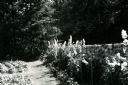
| Date: | 1954 |
|---|---|
| Description: | Tall flowers, possibly delphiniums and hollyhocks, grow between a stone wall and a grass path. A vegetable garden grows on the other side of the path, and ... |

| Date: | 1993 |
|---|---|
| Description: | A path winds through dense ground cover and under tall evergreen trees past the guest house towards the maid's quarters and the main lodge. The guest house... |
If you didn't find the material you searched for, our Library Reference Staff can help.
Call our reference desk at 608-264-6535 or email us at: