 Filter: Categories of Wisconsin Historical Images
Filter: Subject of Trails
Filter: Year of 1900-1999
Filter: Subject of human settlements
Filter: Year of 1930-1939
Filter: Categories of Wisconsin Historical Images
Filter: Subject of Trails
Filter: Year of 1900-1999
Filter: Subject of human settlements
Filter: Year of 1930-1939
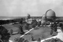
| Date: | 1935 |
|---|---|
| Description: | Elevated exterior view of Yerkes Observatory. Geneva Lake is in the background, left. Roads and sidewalks cross the sweeping, well tended lawns. The desi... |

| Date: | 1936 |
|---|---|
| Description: | This map is red and black ink on tracing cloth and is oriented with north to the upper left. This hand-drawn map shows a central portion of the military ro... |
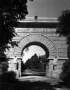
| Date: | 1936 |
|---|---|
| Description: | Camp Randall Memorial Arch with a gated path. |
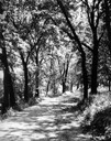
| Date: | 1930 |
|---|---|
| Description: | View of the Lakeshore Path in Bascom Woods by Lake Mendota, later dedicated the Howard M. Temin Lake Shore Path on the University of Wisconsin-Madison camp... |

| Date: | 1930 |
|---|---|
| Description: | View of heating plants and shops on the University of Wisconsin campus. |

| Date: | 1932 |
|---|---|
| Description: | Exterior view of University of Wisconsin-Madison College of Agriculture building on campus, as seen from the west. A car can be seen on a tree-lined road o... |

| Date: | 1932 |
|---|---|
| Description: | Exterior view from the west of University of Wisconsin-Madison College of Agriculture on a hill on campus. |

| Date: | 1930 |
|---|---|
| Description: | Walkway and stairs leading to Bascom Hall (formerly Main Hall) on the University of Wisconsin-Madison campus. Trees and bushes are planted on the lawn betw... |

| Date: | 1930 |
|---|---|
| Description: | Walkway near back of building with lawn and trees on the University of Wisconsin-Madison campus. |
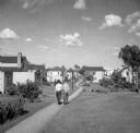
| Date: | 1939 |
|---|---|
| Description: | Two people, most likely a woman or girl, and a boy, are walking on a footpath with houses and young trees on either side of the path. |

| Date: | 1939 |
|---|---|
| Description: | Flag pole with limestone carving of women and men by Alonzo Hauser, who was appointed by the Farm Security Administration, at its base. The sculpture was b... |

| Date: | 1930 |
|---|---|
| Description: | Housing development. A man and a woman walk on the sidewalk in a tidy housing development. Greenbelt was one of three planned communities along with Greend... |
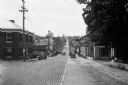
| Date: | 1930 |
|---|---|
| Description: | View down Midland Trail. Automobiles are parked on either side of the street outside an Amoco Station and other stores and dwellings. |

| Date: | 1930 |
|---|---|
| Description: | This map shows Indian trails through Wisconsin counties. The trail are in red ink. Lake Michigan, Green Bay, Lake Superior, and the Wisconsin River are lab... |

| Date: | 1930 |
|---|---|
| Description: | A boy and girl walk down a path. She has her hand on his shoulder, and is wearing a dress and hat carrying a sack. He is dressed in shirt, knickers, stocki... |

| Date: | 1935 |
|---|---|
| Description: | This topographical map of the forest preserve shows highways, roads, trails, telephone lines, Native American reservations, Ranger sub-stations, state nurs... |

| Date: | 1937 |
|---|---|
| Description: | This is map 4 from a set of 4 taken from an atlas. The map includes a legend in the lower left corner of roads, trails, county lines, town lines, section l... |

| Date: | 1936 |
|---|---|
| Description: | This map shows campsites, trails, auto roads, surrounding townships, and points of interest, by including pictorial illustrations. Includes an inserted map... |
If you didn't find the material you searched for, our Library Reference Staff can help.
Call our reference desk at 608-264-6535 or email us at: