 Filter: Categories of Wisconsin Historical Images
Filter: Subject of Trails
Filter: Year of 1900-1999
Filter: Subject of roads
Filter: Categories of Wisconsin Historical Images
Filter: Subject of Trails
Filter: Year of 1900-1999
Filter: Subject of roads
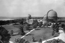
| Date: | 1935 |
|---|---|
| Description: | Elevated exterior view of Yerkes Observatory. Geneva Lake is in the background, left. Roads and sidewalks cross the sweeping, well tended lawns. The desi... |

| Date: | 1936 |
|---|---|
| Description: | This map is red and black ink on tracing cloth and is oriented with north to the upper left. This hand-drawn map shows a central portion of the military ro... |
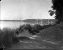
| Date: | 1926 |
|---|---|
| Description: | Lake Mendota, including Fraternity Row and east side shoreline, taken from the lake path on University Bay Drive. |

| Date: | 1923 |
|---|---|
| Description: | Aerial view of the Wisconsin Historical Society, Science Hall, and Bascom Hall on Bascom Hill on the University of Wisconsin-Madison campus. Lake Mendota i... |
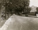
| Date: | 1922 |
|---|---|
| Description: | View of tree-lined Linden Drive includes parked motorcycles and automobiles on the University of Wisconsin campus. |
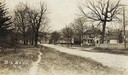
| Date: | 1918 |
|---|---|
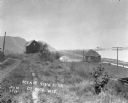
| Description: | View of a road and houses. Caption reads: "Big Bend, Wis." |

| Date: | 1910 |
|---|---|
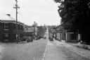
| Description: | View of an unpaved street in Prairie Farm, lined on the left with multiple buildings, including three churches. Along the right side of the road is a dirt ... |

| Date: | 1907 |
|---|---|
| Description: | Elevated view looking northeast from the chimney of the Power Plant on University Avenue. The Chemistry Building is in the foreground, and Bascom Hall and ... |

| Date: | 08 17 1927 |
|---|---|
| Description: | Elevated view of dormitories on the University of Wisconsin-Madison campus. Adams, Van Hise and Tripp Halls with Lake Mendota in the background. Picnic Poi... |

| Date: | 1907 |
|---|---|
| Description: | Elevated view looking northeast from the chimney of the Power Plant on University Avenue. The Chemistry Building is in the foreground, and Bascom Hall and ... |

| Date: | 1909 |
|---|---|
| Description: | Elevated view over University Avenue towards the northeast of Bascom Hall and Lake Mendota on the University of Wisconsin-Madison campus. The Chemistry Bui... |
| Date: | 1925 |
|---|---|
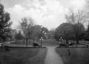
| Description: | Cars parked in the circular drive on the campus grounds at Bessie Tift College. The tree dotted lawn extends in all directions. |
| Date: | 1918 |
|---|---|
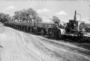
| Description: | A man stands in front of a Holt Caterpillar tractor at Camp Travis, named in 1917. The tractor pulls a train of wagons on a dirt path. Several men work in ... |
| Date: | 1920 |
|---|---|
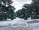
| Description: | A view of the Carithers Memorial Gate at the entrance to the Bessie Tift College campus, consisting of four brick pillars with globe lamps on top flanking ... |
| Date: | 1930 |
|---|---|
| Description: | View down Midland Trail. Automobiles are parked on either side of the street outside an Amoco Station and other stores and dwellings. |
| Date: | 1914 |
|---|---|
| Description: | View down path along rough road towards a building labeled "No. 4". The De Soto Depot, railroad tracks, a boxcar, and the Mississippi River are below on th... |

| Date: | 1968 |
|---|---|
| Description: | The map shows fire towers, public camp grounds, roads, snow mobile & riding trails, trout lakes, foot trails, railroads, and National Forest boundaries. |

| Date: | 1994 |
|---|---|
| Description: | This brochure consists of a series of 16 maps of the Elroy-Sparta State Trail and the 400 State Trail, as well as the Omaha Trail between Sparta and Camp D... |

| Date: | 1994 |
|---|---|
| Description: | This brochure presents a series of 16 maps of the Glacial Drumlin Trail and the New Berlin Trail. The Glacial Drumlin Trail consists of 53 miles of bike tr... |
If you didn't find the material you searched for, our Library Reference Staff can help.
Call our reference desk at 608-264-6535 or email us at:
