 Filter: Categories of Wisconsin Historical Images
Filter: Subject of Trails
Filter: Year of 1900-1999
Filter: Subject of trails
Filter: Categories of Wisconsin Historical Images
Filter: Subject of Trails
Filter: Year of 1900-1999
Filter: Subject of trails

| Date: | 1922 |
|---|---|
| Description: | A map of Iron County, Wisconsin, shows sections and the towns of Upson, Hurley, Hamilton, Saxon, and Mercer, lakes and streams, villages, railroads, roads ... |

| Date: | 1908 |
|---|---|
| Description: | Ruth and Miriam Bennett on a wooden walkway at Mirror Lake. |

| Date: | 1970 |
|---|---|
| Description: | A map showing highlighted snowmobile trails, ice crossings, and supporting businesses in the towns of Stephenson and Silver Cliff in Marinette County and ... |

| Date: | 1969 |
|---|---|
| Description: | A map of the Elroy-Sparta State Trail and the surrounding area, showing the townships, the towns of Cashton, Sparta, in the west, and Union Center and Elro... |

| Date: | 1916 |
|---|---|
| Description: | This Wisconsin Conservation Commission map from 1916 shows Peninsula State Park in the Town of Gibraltar, Door County, Wisconsin. Depicted are open and pla... |

| Date: | 1916 |
|---|---|
| Description: | This version of a 1916 Wisconsin Conservation Commission map shows Peninsula State Park in the Town of Gibraltar, Door County, Wisconsin. Depicted are open... |

| Date: | 1952 |
|---|---|
| Description: | This 1952 map shows the trails, roads, and railroads through the counties of Ashland, Bayfield, Sawyer, Price, Iron, and Vilas. Also shown are lakes, river... |

| Date: | 1925 |
|---|---|
| Description: | This 1925 map of Ashland County, Wisconsin, shows the township and range system, towns, sections, cities and villages, the Bad River Indian Reservation, ra... |

| Date: | 1952 |
|---|---|
| Description: | This 1952 map of the northern parts of Bayfield and Douglas counties, Wisconsin, shows points established by E.T. Sweet in 1877, road points confirmed by S... |

| Date: | 1952 |
|---|---|
| Description: | This map of the northern parts of the Chequamegon Bay area in Bayfield and Ashland counties, Wisconsin, shows trails, roads, railroads, stations, the towns... |
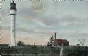
| Date: | 1913 |
|---|---|
| Description: | Hand-colored postcard showing the lighthouse and fog signal at Devil's Island in the Apostle Islands. Caption reads: "Apostle Islands, Wis. Devil's Island,... |

| Date: | 1964 |
|---|---|
| Description: | This 1964 maps shows roads, boat landings and marinas, campgrounds, canoe trails and portages, and lakes and streams in parts of Vilas, Oneida, and Iron co... |

| Date: | 1974 |
|---|---|
| Description: | This 1968 map identifies resorts in the Lac du Flambeau Indian Reservation region of Wisconsin, covering parts of Iron, Vilas, Oneida, and Price counties. ... |

| Date: | 1941 |
|---|---|
| Description: | This 1941 map covers Washburn County, Wisconsin, as well as western Sawyer, eastern Burnett, and northeastern Polk counties. It shows the locations of tour... |

| Date: | 1975 |
|---|---|
| Description: | This 1975 road map of Columbia County, Wisconsin, shows the location of historic sites in the county but lacks a key to those sites. It includes an inset m... |

| Date: | 1974 |
|---|---|
| Description: | This 1974 map is a reproduction of the original survey maps of the Four Lakes region of Dane County, Wisconsin. It shows sections, lakes, rivers, wetlands,... |

| Date: | 1920 |
|---|---|
| Description: | This map of Devil's Lake State Park in Sauk County, Wisconsin, shows the park limits, railroads, roads, creeks, trails, and points of interest in the area.... |

| Date: | 1926 |
|---|---|
| Description: | Map showing Devil's Lake State Park limits, railroads, roads, creeks, trails, and park sites. Accompanying text about the location, natural features, attra... |

| Date: | 1943 |
|---|---|
| Description: | Shows portage trail, monuments, and hydrography in part of Solon Springs township, Douglas County, Wis. "All sections are in T45N, R11W." |

| Date: | 1970 |
|---|---|
| Description: | This pictorial map of Dunn County, Wisconsin, from the 1970s depicts historical events that occurred in the county. It shows cemeteries, churches, schools,... |
If you didn't find the material you searched for, our Library Reference Staff can help.
Call our reference desk at 608-264-6535 or email us at: