Filter: Categories of Wisconsin Historical Images
Filter: Subject of Trails
Filter: Year of 1900-1999
Filter: Year of 1940-1949
Filter: Subject of land
Filter: Categories of Wisconsin Historical Images
Filter: Subject of Trails
Filter: Year of 1900-1999
Filter: Year of 1940-1949
Filter: Subject of land

| Date: | 1945 |
|---|---|
| Description: | View of the lower campus of the University of Wisconsin-Madison includes Bascom Hill, Wisconsin Historical Society, Memorial Union and the Armory (Red Gym ... |

| Date: | 1945 |
|---|---|
| Description: | Aerial view of Bascom Hill, Bascom Hall, Wisconsin Historical Society on the University of Wisconsin Madison campus with Lake Mendota on the right. |
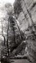
| Date: | 1945 |
|---|---|
| Description: | Tower Hill State Park trail leading to the top of the shot tower shaft. |
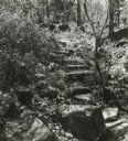
| Date: | 1945 |
|---|---|
| Description: | Tower Hill State Park trail to the top of the shot tower shaft. |
| Date: | 1940 |
|---|---|
| Description: | A view of a cabin and the tent grounds of Nordland Camp for boys, operated as an auxiliary of the German-American Bund, the American Nazi Organization. A f... |

| Date: | 1941 |
|---|---|
| Description: | This 1941 map covers Washburn County, Wisconsin, as well as western Sawyer, eastern Burnett, and northeastern Polk counties. It shows the locations of tour... |

| Date: | 1943 |
|---|---|
| Description: | Shows portage trail, monuments, and hydrography in part of Solon Springs township, Douglas County, Wis. "All sections are in T45N, R11W." |

| Date: | 1941 |
|---|---|
| Description: | This map is ink and watercolor on cardboard and shows Native American legends and villages pictorially. Trails are also shown. |

| Date: | 1941 |
|---|---|
| Description: | This is map one of three maps that show trails, roads and fire lanes, utilities, resorts, submerged lakes, vegetation, flowage right lands, and timber righ... |

| Date: | 1949 |
|---|---|
| Description: | This pictorial map shows the United States west of the Mississippi, including Indian Tribes, historic trails, forts, trading posts, mountain ranges, lakes ... |

| Date: | 1948 |
|---|---|
| Description: | This illustrated map shows major westward trails from 1785 to 1866: Old Oregon Trail and its deviations, Old Spanish Trail, Lewis and Clark route, Santa Fe... |

| Date: | 1949 |
|---|---|
| Description: | This map shows points of interest, historic sites, buildings, trails, roads, and general animal and plant locations. |
If you didn't find the material you searched for, our Library Reference Staff can help.
Call our reference desk at 608-264-6535 or email us at: