 Filter: Categories of Wisconsin Historical Images
Filter: Subject of Trails
Filter: Year of 1900-1999
Filter: Categories of Wisconsin Historical Images
Filter: Subject of Trails
Filter: Year of 1900-1999
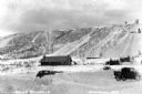
| Date: | 1935 |
|---|---|
| Description: | View of Mount Valhalla during the winter near Washburn. There is a building and a few automobiles parked at the bottom of a large hill covered in snow. The... |

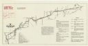
| Date: | 1968 |
|---|---|
| Description: | The map shows fire towers, public camp grounds, roads, snow mobile & riding trails, trout lakes, foot trails, railroads, and National Forest boundaries. |

| Date: | 1930 |
|---|---|
| Description: | This map shows Indian trails through Wisconsin counties. The trail are in red ink. Lake Michigan, Green Bay, Lake Superior, and the Wisconsin River are lab... |

| Date: | 1994 |
|---|---|
| Description: | This brochure consists of a series of 16 maps of the Elroy-Sparta State Trail and the 400 State Trail, as well as the Omaha Trail between Sparta and Camp D... |

| Date: | 1919 |
|---|---|
| Description: | This map depicts the route of the 1842 overland trip by wagon made by the Reverend Alfred Brunson and some copper miners from Prairie du Chien to the mouth... |

| Date: | 1920 |
|---|---|
| Description: | Shows 10 land and water trails along rivers and other bodies of water in northern Wisconsin and the Upper Peninsula of Michigan; each trail numbered and de... |

| Date: | 1994 |
|---|---|
| Description: | This brochure presents a series of 16 maps of the Glacial Drumlin Trail and the New Berlin Trail. The Glacial Drumlin Trail consists of 53 miles of bike tr... |

| Date: | 1916 |
|---|---|
| Description: | This map shows the locations of hunting and fishing resorts in the northern Wisconsin counties of Forest, Iron, Oneida, and Vilas, and in Gogebic County in... |

| Date: | 1994 |
|---|---|
| Description: | This brochure consists of a series of 16 maps of the Military Ridge State Park Trail and the Sugar River State Trail. In all, 62 miles of bike trails and 1... |

| Date: | 1904 |
|---|---|
| Description: | A map that shows the location of the lakes and resorts in northeastern Wisconsin that were reachable by the Chicago and North Western Railway. Shown in the... |

| Date: | 1930 |
|---|---|
| Description: | A boy and girl walk down a path. She has her hand on his shoulder, and is wearing a dress and hat carrying a sack. He is dressed in shirt, knickers, stocki... |

| Date: | 1938 |
|---|---|
| Description: | View of a house on Nebraska Row on Madeline Island. In the foreground is a flag pole, bench, path, lawn and trees. On the left are docks from the lake shor... |
| Date: | 08 1976 |
|---|---|
| Description: | A map that shows the trail route and detours from Rice Lake, in Barron County, through Washburn and Sawyer counties, to Park Falls, in Price County. A mile... |

| Date: | 1920 |
|---|---|
| Description: | A pedestrian path along the Wisconsin River. An advertisement for J.M. Brophy general store is painted on the rock formations along the path. |
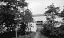
| Date: | 1921 |
|---|---|
| Description: | A walkway with rustic railing leads to the Hotz family boathouse on Europe Lake. A well-worn path leads downhill to the water. |
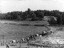
| Date: | 08 1983 |
|---|---|
| Description: | "Late in the day, the cows return for milking on the Batzler farm." |

| Date: | 04 1984 |
|---|---|
| Description: | The 'Yellowstone Trail' at one time passed through the village. Les Beck displays a sign next to a present day road sign." |
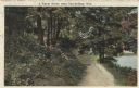
| Date: | 08 1917 |
|---|---|
| Description: | Colorized postcard of a rural scene. A dirt path winds through the forest, and a pond or stream can be seen in the lower right corner. Text above reads: "A... |
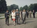
| Date: | 1991 |
|---|---|
| Description: | Mary Robinson, President of Ireland, escorting Speaker of the House of Representative Thomas Foley, who was heading a house leadership trip to Ireland. To ... |
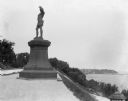
| Date: | 09 1900 |
|---|---|
| Description: | View of a statue in Juneau Park, created by American sculptor Anne Whitney in 1887. The statue is a replica of the original which resides in Boston, Massac... |
If you didn't find the material you searched for, our Library Reference Staff can help.
Call our reference desk at 608-264-6535 or email us at: