 Filter: Categories of Wisconsin Historical Images
Filter: Subject of Trails
Filter: Year of 1900-1999
Filter: Year of 1950-1959
Filter: Categories of Wisconsin Historical Images
Filter: Subject of Trails
Filter: Year of 1900-1999
Filter: Year of 1950-1959

| Date: | 1956 |
|---|---|
| Description: | Aerial view of lower University of Wisconsin-Madison campus with demolition of buildings on both sides of the Armory-Gymnasium to make space for future pla... |
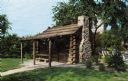
| Date: | 1955 |
|---|---|
| Description: | View toward the front entrance of the cabin with a stone chimney on the right. |
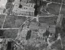
| Date: | 1956 |
|---|---|
| Description: | Aerial view of Birge and Bascom Halls (formerly Main Hall) on the University of Wisconsin-Madison campus. Birge Hall (foreground) with addition under cons... |

| Date: | 07 06 1950 |
|---|---|
| Description: | Girl Scouts carry water up a hill to their camp site at Camp Greenwood, a day camp at Picnic Point for Intermediate Girl Scouts between the ages of 10 and ... |
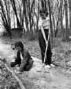
| Date: | 05 15 1954 |
|---|---|
| Description: | Two campers working on a trail during the seventh and eighth grade Girl Scouts play day at the Black Hawk Council's Camp Brandenburg. Lois Lischeske of Mad... |

| Date: | 1952 |
|---|---|
| Description: | This 1952 map shows the trails, roads, and railroads through the counties of Ashland, Bayfield, Sawyer, Price, Iron, and Vilas. Also shown are lakes, river... |

| Date: | 1952 |
|---|---|
| Description: | This 1952 map of the northern parts of Bayfield and Douglas counties, Wisconsin, shows points established by E.T. Sweet in 1877, road points confirmed by S... |

| Date: | 1952 |
|---|---|
| Description: | This map of the northern parts of the Chequamegon Bay area in Bayfield and Ashland counties, Wisconsin, shows trails, roads, railroads, stations, the towns... |

| Date: | 1953 |
|---|---|
| Description: | "Compliments of the Douglas County Highway Department"--Top margin. Shows federal highways, state trunk highways, county highways, town roads, unimproved ... |

| Date: | 1952 |
|---|---|
| Description: | This map shows roads, foot and canoe trails, railroads, resorts, lookout towers, camps, national and state forests, Indian reservation, and types of fish i... |

| Date: | 1952 |
|---|---|
| Description: | This map shows lakes, rivers, railroads, highways, roads, hunting grounds and trails around Flambeau Flowage and Boulder Junction in the north, to Brantwoo... |

| Date: | 1952 |
|---|---|
| Description: | This map shows hunting areas, lakes, rivers, railroads, highways, roads, and trails around Clam Lake, Glidden, and Flambeau Flowage in the north, to Hawkin... |
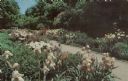
| Date: | 1958 |
|---|---|
| Description: | Irises along a path in Whitnall Park. Text on reverse reads: "Over 400 varieties of iris grow in the perennial borders. Thousands of blooms can be seen ... |

| Date: | 1950 |
|---|---|
| Description: | Sunshine brightens autumn oak and maple leaves along a narrow road identified as Razorback Trail. There are also birch and evergreen trees in the woods. |

| Date: | 1955 |
|---|---|
| Description: | View down worn path towards several tents pitched on platforms along a slope. The caption on the back reads: "Tents for summer school students in the Eagle... |

| Date: | 1950 |
|---|---|
| Description: | View towards man using a TD-24 to load logs onto a truck. Mountains are in the background. Subject: "TD-24 — Lumbering." Where Taken: "Pac." Information wi... |

| Date: | 1950 |
|---|---|
| Description: | View down trail towards a man using a TD-24. Mountains are in the background. Subject: "TD-24 — Lumbering." Where Taken: "Pac." Information with photograph... |
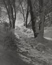
| Date: | 1950 |
|---|---|
| Description: | A snowy walking trail in a park, through the trees, in the snow by moonlight. |
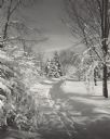
| Date: | 1955 |
|---|---|
| Description: | A path in Brown Deer Park after a snow storm. Fresh snow is covering the ground and trees. |
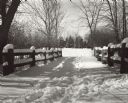
| Date: | 1956 |
|---|---|
| Description: | Snow scene of a lane line on each side with timber fences, possibly a bridge. Trees are overhead and in the distance. |
If you didn't find the material you searched for, our Library Reference Staff can help.
Call our reference desk at 608-264-6535 or email us at: