 Filter: Categories of Wisconsin Historical Images
Filter: Subject of Trails
Filter: Year of 1900-1999
Filter: Year of 1970-1979
Filter: Categories of Wisconsin Historical Images
Filter: Subject of Trails
Filter: Year of 1900-1999
Filter: Year of 1970-1979
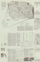
| Date: | 1976 |
|---|---|
| Description: | This is a guide to the original bikeway and additions. The front of the guide includes a map of Wisconsin, a map of the entire bikeway, and one route map. ... |
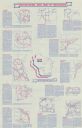
| Date: | 1976 |
|---|---|
| Description: | Intended for tourists, the front of this guide includes twelve county bicycle maps and text. The reverse includes four maps of state trails and nine maps o... |
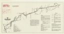
| Date: | 08 1976 |
|---|---|
| Description: | A map that shows the trail route and detours from Rice Lake, in Barron County, through Washburn and Sawyer counties, to Park Falls, in Price County. A mile... |

| Date: | 1970 |
|---|---|
| Description: | A map showing highlighted snowmobile trails, ice crossings, and supporting businesses in the towns of Stephenson and Silver Cliff in Marinette County and ... |

| Date: | 1974 |
|---|---|
| Description: | This 1968 map identifies resorts in the Lac du Flambeau Indian Reservation region of Wisconsin, covering parts of Iron, Vilas, Oneida, and Price counties. ... |

| Date: | 1975 |
|---|---|
| Description: | This 1975 road map of Columbia County, Wisconsin, shows the location of historic sites in the county but lacks a key to those sites. It includes an inset m... |

| Date: | 1974 |
|---|---|
| Description: | This 1974 map is a reproduction of the original survey maps of the Four Lakes region of Dane County, Wisconsin. It shows sections, lakes, rivers, wetlands,... |

| Date: | 1970 |
|---|---|
| Description: | This pictorial map of Dunn County, Wisconsin, from the 1970s depicts historical events that occurred in the county. It shows cemeteries, churches, schools,... |

| Date: | 1975 |
|---|---|
| Description: | This map shows settlers, Indian trails, roads, marshes, and forests as they appeared in 1800-1840. "A bicentennial map of Racine County for the benefit of ... |

| Date: | 1973 |
|---|---|
| Description: | Map shows sections, trails, roads, and locations of ancient burial grounds, hills, groves, and settlers. Printed in brown ink. |

| Date: | 1970 |
|---|---|
| Description: | Map features a legend of roads, trails, points of interest, buildings, and types of vegetation. To the right are "ARBORETUM REGULATIONS" regarding hours, p... |

| Date: | 1974 |
|---|---|
| Description: | A map of Dane County from the Charles Brown Atlas. A hand-drawn blue line marks the Black Hawk Trail. |

| Date: | 1975 |
|---|---|
| Description: | This map shows nature trails, public attractions, public hunting and fishing grounds, dams, waysides, lakes, highways, and roads. The upper right corner in... |
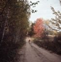
| Date: | 10 1970 |
|---|---|
| Description: | Two people are walking down a dirt path lined with trees turning fall colors. |

| Date: | 10 1978 |
|---|---|
| Description: | Melvin and Sadie Tvedt of Mount Horeb, walking down a trail at Governor Dodge State Park. |
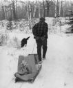
| Date: | 1976 |
|---|---|
| Description: | Elderly man pulling a sled loaded with packages and bags. He is wearing a plaid coat. His dog is sniffing the snow. Trees cover a snow covered berm in the ... |
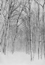
| Date: | 1976 |
|---|---|
| Description: | Snow covered Birch trees line a path in a forest after a storm. |
If you didn't find the material you searched for, our Library Reference Staff can help.
Call our reference desk at 608-264-6535 or email us at: