 Filter: Categories of Wisconsin Historical Images
Filter: Subject of Transportation
Filter: Community of Cedarburg
Filter: Categories of Wisconsin Historical Images
Filter: Subject of Transportation
Filter: Community of Cedarburg
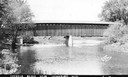
| Date: | 1940 |
|---|---|
| Description: | Exterior view of the last covered bridge in Wisconsin. Caption reads: "Covered Bridge Near Cedarburg, Wis." |

| Date: | 1882 |
|---|---|
| Description: | This map of Cedarburg is a bird's-eye map with an inset of Cedarburg Brewery. Relief is shown pictorially and the map includes an index to buildings. |

| Date: | 2007 |
|---|---|
| Description: | This map of Cedarbug is a bird's-eye map with 8 inset views and an index. The map is a print out of the original map dated 1892 held at the Cedarburg Cultu... |
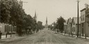
| Date: | 1907 |
|---|---|
| Description: | View down center of unpaved street in Cedarburg, with a large church at the far end. |
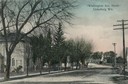
| Date: | 1907 |
|---|---|
| Description: | View across Washington Avenue. A man is standing in the street near the curb. Caption reads: "Cedarburg, Wis., Washington Avenue looking North." |
| Date: | 1905 |
|---|---|
| Description: | North view down Washington Avenue. Caption reads: "'Washington Ave., North' Cedarburg Wis." |
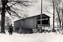
| Date: | 1934 |
|---|---|
| Description: | Southwest view of a covered bridge over Cedar Creek, with a man walking in the snow nearby. |
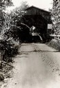
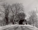
| Date: | 1933 |
|---|---|
| Description: | View down dirt road towards the covered bridge over Cedar Creek, south approach. |
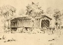
| Date: | 1940 |
|---|---|
| Description: | Drawing of a covered bridge in Cedarburg. |
| Date: | 1940 |
|---|---|
| Description: | Last covered bridge to remain standing in Wisconsin. In the distance an automobile is parked on the side of the road in the shade of a tree. Caption along ... |
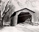
| Date: | 1957 |
|---|---|
| Description: | Covered bridge over Cedar Creek in Ozaukee County on highway, about one mile north of Cedarburg. The last remaining covered bridge in Wisconsin. Snow is on... |
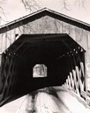
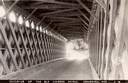
| Date: | 1957 |
|---|---|
| Description: | View through the covered bridge over Cedar Creek in Ozaukee County on highway, about one mile north of Cedarburg. The last remaining covered bridge in Wisc... |
| Date: | 1957 |
|---|---|
| Description: | Covered bridge over Cedar Creek in Ozaukee County on highway, about one mile north of Cedarburg. The last remaining covered bridge in Wisconsin. Snow is on... |
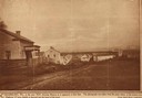
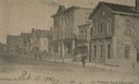
| Date: | 1850 |
|---|---|
| Description: | Main Street in Cedarburg. Includes text which reads: "Cedarburg, Wis., in the year 1850, showing Main Street as it appeared at that time. The photograph wa... |
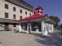
| Date: | 2008 |
|---|---|
| Description: | Alexander C. Eschweiler, a well-known architect in Milwaukee, designed this exotic station for the Wadhams Oil and Grease Company of Milwaukee in 1926. |
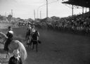
| Date: | 07 04 1947 |
|---|---|
| Description: | Ring at the Cedarburg horse show with cowgirls and cowboys. On the right are crowd-filled bleachers behind fence. |

| Date: | 1967 |
|---|---|
| Description: | This map of Cedarburg includes a list of historic buildings in the left margin. The map was created by the Ozaukee County Historical Society for Cedarburg'... |
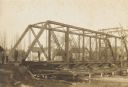
| Date: | 1906 |
|---|---|
| Description: | Steel span railroad bridge under construction over Cedar Creek. |

| Date: | 1938 |
|---|---|
| Description: | This map shows plat of town, boundary lines of assessors blocks, land ownership by name, local streets, railroads, wards, lots, and parts of Cedar Creek. T... |

| Date: | 1962 |
|---|---|
| Description: | View from side of road towards the covered bridge, with the historical marker on the right. "This bridge was built by the town of Cedarburg on petition of ... |
If you didn't find the material you searched for, our Library Reference Staff can help.
Call our reference desk at 608-264-6535 or email us at: