Visit our other Wisconsin Historical Society websites!
 Filter: Categories of Wisconsin Historical Images
Filter: Subject of Trees
Filter: Type of Photograph
Filter: Subject of intellectual life
Filter: Categories of Wisconsin Historical Images
Filter: Subject of Trees
Filter: Type of Photograph
Filter: Subject of intellectual life

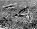
| Date: | 1958 |
|---|---|
| Description: | Aerial view of contour strip farming with the Obert Olstad farm in foreground. The Carl Backum farm is in the background. |
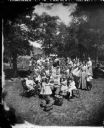
| Date: | 1873 |
|---|---|
| Description: | Slightly elevated view of a large, multi-generational Norwegian family and friends gathered for a picnic celebration. In the foreground are picnic baskets ... |

| Date: | 06 27 1927 |
|---|---|
| Description: | Aerial view of the effigy mound on Henry Wehmhoff's Riverview Farm. State Trunk Highway 83 runs through the effigy. |
| Date: | 08 1905 |
|---|---|
| Description: | A visitor takes in the sight of three linear burial mounds at the Sure-Johnson mound group south of McFarland, Wisconsin. |

| Date: | 1956 |
|---|---|
| Description: | Aerial view of the South Park Street interchange. |

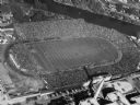
| Date: | 1908 |
|---|---|
| Description: | Aerial view of Camp Randall Field on the University of Wisconsin-Madison campus. University Heights is in the background. |

| Date: | 1928 |
|---|---|
| Description: | Aerial view of the Wisconsin State Capitol, looking northeast. The Park Hotel on the corner of W. Main Street and S. Carroll Street, is in the foreground. |

| Date: | 01 1934 |
|---|---|
| Description: | Aerial view of New Butler, in Waukesha County. |
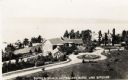
| Date: | 1925 |
|---|---|
| Description: | Aerial view of Woods' Manor on shores of Madeline Island. The manor was built in 1900 for summer resident Colonel Frederick Woods from Nebraska. |
| Date: | |
|---|---|
| Description: | Aerial view of "Walden", the estate of Cyrus McCormick, Jr. |
| Date: | 1952 |
|---|---|
| Description: | Aerial view of City Stadium, former home of the Green Bay Packers from 1925 to 1956. Currently it is the home of the Green Bay East High School football te... |

| Date: | 1908 |
|---|---|
| Description: | A panoramic aerial view of the Isthmus taken from a kite. Lake Mendota is to the right in the background with Picnic Point jutting into the lake. The photo... |

| Date: | |
|---|---|
| Description: | A cross with the inscription "Morts Pour La Patrie." Captioned "Dead for the Country," a familiar sign in the valley of the Marne. |
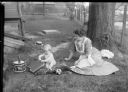
| Date: | 1903 |
|---|---|
| Description: | Beatrice C. Gesell and Gerhard Gesell, Jr. play out-of-doors. While mother watches the baby sits on a pillow playing with a volume titled "Educational Pro... |
| Date: | 1919 |
|---|---|
| Description: | Elevated view of a four-footed American Indian effigy mound on the grounds of the Mendota State Hospital (Mendota Mental Health Institute). |

| Date: | 1956 |
|---|---|
| Description: | Aerial view of the Chicago, Milwaukee, and St. Paul Railroad station, roundhouse, and yard at the intersection of West Washington Avenue (across lower left... |

| Date: | 1964 |
|---|---|
| Description: | Aerial view of the Milwaukee County Zoo grounds nearing its completion. |
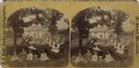
| Date: | 1877 |
|---|---|
| Description: | Stereograph of Rev. A. Jacobson, family and visitors, Perry, Wis." from Dahl's 1877 "Catalogue of Stereoscopic Views." Jacobson (1836-1910) immigrated to t... |
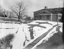
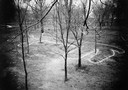
| Date: | |
|---|---|
| Description: | A turtle effigy mound on the University of Wisconsin-Madison campus, outlined by melting snow. |
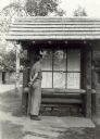
| Date: | 1939 |
|---|---|
| Description: | Man looking at a map of Copper Falls State Park, which is on display to assist visitors. |
If you didn't find the material you searched for, our Library Reference Staff can help.
Call our reference desk at 608-264-6535 or email us at: