 Filter: Categories of Wisconsin Historical Images
Filter: Subject of Trees
Filter: Year of 1800-1899
Filter: Year of 1850-1859
Filter: Categories of Wisconsin Historical Images
Filter: Subject of Trees
Filter: Year of 1800-1899
Filter: Year of 1850-1859
| Date: | 1856 |
|---|---|
| Description: | Painting by S.M. Brookes of the Wisconsin Heights Battlefield. |

| Date: | 1856 |
|---|---|
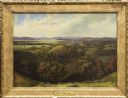
| Description: | This landscape painting by Samuel Marsden Brookes and Thomas H. Stevenson depicts a broad view of the confluence of Bad Axe and Mississippi Rivers; site of... |

| Date: | 10 1852 |
|---|---|
| Description: | Landscape view of the river looking downstream from Fort Snelling, Minnesota Territory. An expanse of placid river water fills the center of the drawing an... |
| Date: | 1851 |
|---|---|
| Description: | A watercolor view of Madison. Prominent on the left side of King Street is the Madison Hotel. |

| Date: | 1855 |
|---|---|
| Description: | Bird's-eye view of Madison. "Taken from the Water Cure, South Side of Lake Monona, 1855." |

| Date: | 1852 |
|---|---|
| Description: | Illustration of four Indians on Madeline Island with a canoe in the water on the shore. |
| Date: | 1856 |
|---|---|
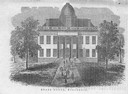
| Description: | The Wisconsin State Capitol (the second State Capitol, the first in Madison). Illustration from the American Encyclopedia, Columbus, 1859. |

| Date: | 1850 |
|---|---|
| Description: | Painting depicting Chippewa Falls and the first sawmill on the Chippewa River, built by Jean Brunet. The residence of H.S. Allen, one of the owners of the... |

| Date: | 1850 |
|---|---|
| Description: | Elevated view of the Lake Superior shoreline, with terraces leading to the beach. A canoe is on the shoreline. |

| Date: | 1850 |
|---|---|
| Description: | Pastoral scene depicting a small bay on the Island of St. Ignace in Lake Superior with canoes on the rocky beach, two men conversing on a blanket in the fo... |

| Date: | 1850 |
|---|---|
| Description: | Pic Island on the north shore of Lake Superior. |

| Date: | 1856 |
|---|---|
| Description: | View looking west from Lake Michigan with several steam ships and sailing vessels in harbor. There is a lighthouse to left of center, along shoreline. |
| Date: | 10 17 1853 |
|---|---|
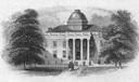
| Description: | An engraving of the second Wisconsin State Capitol (the first built in Madison) that appeared on the notes of the State Bank of Madison, the first bank org... |
| Date: | 1850 |
|---|---|
| Description: | Chippewa Indian Sugar Camp. Plate 61, preceding p. 199, vol. I, The Indian tribes of the United States: their history antiquities, customs, religion, ar... |
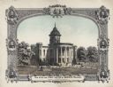
| Date: | 1857 |
|---|---|
| Description: | Lithograph of the Wisconsin State Capitol, surrounded by portraits of Wisconsin Statesmen. Governor Bashford hired the Madison architectural firm Kutzbock ... |

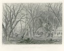
| Date: | 1852 |
|---|---|
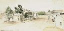
| Description: | Pencil drawing of Madison landscape as seen from University Hill. The main street in the center is State Street, and the building with Greek columns in the... |
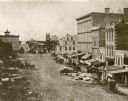
| Date: | 1859 |
|---|---|
| Description: | Daguerreotype of elevated view of Pinckney Street, looking northwest. View includes the American House and Bruen's Block, both on the corner of East Washin... |

| Date: | 1857 |
|---|---|
| Description: | Elevated view of Waukesha with two women wearing dresses with a boy in long pants and tam o'shanter hat in foreground against a split-rail fence. Beyond th... |

| Date: | 1858 |
|---|---|
| Description: | Elevated view from bluff looking down on city, with Lake Michigan in background. Detailed foreground with two boys playing with a grounded kite, while a ma... |
If you didn't find the material you searched for, our Library Reference Staff can help.
Call our reference desk at 608-264-6535 or email us at:
