Filter: Categories of Wisconsin Historical Images
Filter: Subject of Valleys
Filter: Creator Name of Unknown
Filter: Categories of Wisconsin Historical Images
Filter: Subject of Valleys
Filter: Creator Name of Unknown

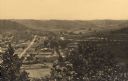
| Date: | 1905 |
|---|---|
| Description: | Elevated view from hill towards Elmwood. Tree-covered bluffs are in the distance. Caption reads: "Bird's Eye View of Elmwood, Wis." |
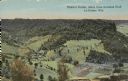
| Date: | |
|---|---|
| Description: | Colorized view of Ebner's Coulee. Caption reads: "Ebner's Coulee, taken from Grandad Bluff, La Crosse, Wis." |
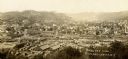
| Date: | 1900 |
|---|---|
| Description: | Elevated view of town from hill. Caption reads: "Birds Eye View Richland Center, Wis". |
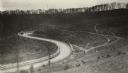
| Date: | 1920 |
|---|---|
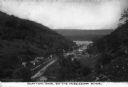
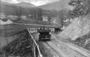
| Description: | Loganville Road in Sauk County taken by the Wisconsin Good Roads Association. The photograph was meant to create a contrast between the new improved road ... |

| Date: | 1911 |
|---|---|
| Description: | Looking north at the Menomonee Valley. Road incorrectly identified on the postcard as twenty-second street viaduct. Pedestrians and carriages are crossing ... |
| Date: | |
|---|---|
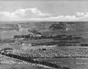
| Description: | Elevated view of a fertile valley in Twin Falls, Idaho. The Snake River can be seen running through the valley. Geological formations can be seen nearby. |
| Date: | |
|---|---|
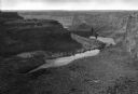
| Description: | Elevated view down the Snake River Canyon toward the Blue Lakes, near Twin Falls. The canyon is formed by the Snake River in the Magic Valley region of sou... |

| Date: | |
|---|---|
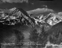
| Description: | Elevated view of a large hotel located in a broad valley near Mount Lafayette and Cannon Mountain. |
| Date: | |
|---|---|
| Description: | An elevated view of the town of Clayton, Iowa, which is nestled in a valley. The Mississippi River can be seen nearby. Caption reads: "Clayton, Iowa, on th... |
| Date: | |
|---|---|
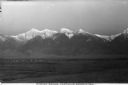
| Description: | A distant view of the Flathead Reservation and the snow-capped Mission Mountains. Caption reads: "Mission Range Flathead Reservation." |
| Date: | |
|---|---|
| Description: | A view of the Spanish Peaks from the Bozeman vicinity. Caption reads: "Spanish Peaks Near Bozeman Montana." |
| Date: | |
|---|---|
| Description: | Elevated view of two cars on a dirt road heading downhill. A town is in the valley below, and mountains are in the distance. |

| Date: | |
|---|---|
| Description: | Elevated view of homes in a valley. In the foreground is a mining-car bridge, numerous buildings, and factory smokestacks. Caption reads: "Cambria, WYO." |

| Date: | |
|---|---|
| Description: | View looking down on cattle grazing in a valley, with a rancher sitting on his horse in the left foreground. Trees span the middle distance, with a view of... |
| Date: | |
|---|---|
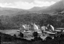
| Description: | Elevated view of the Parsons Pulp Mill, operated from 1902 to 1927, when it was permanently shut down. |

| Date: | |
|---|---|
| Description: | Elevated view of a town and body of water in a valley in Roldal, Norway. Two people in a horse-drawn vehicle are in the foreground on the road leading from... |

| Date: | 11 26 1883 |
|---|---|
| Description: | A hand-drawn map of the Clinch and Powell's Valleys, including the Cumberland Mountains, Powell's Mountains and Clinch Mountains. |

| Date: | |
|---|---|
| Description: | Elevated view of the countryside. Barns and dwellings are among fields and trees. |

| Date: | |
|---|---|
| Description: | View of Lower Falls Paradise Valley featuring a waterfall running down a rock face surrounded by trees. |
If you didn't find the material you searched for, our Library Reference Staff can help.
Call our reference desk at 608-264-6535 or email us at: