 Filter: Categories of Wisconsin Historical Images
Filter: Subject of Water
Filter: Creator Name of Geographical Publishing Company
Filter: Categories of Wisconsin Historical Images
Filter: Subject of Water
Filter: Creator Name of Geographical Publishing Company

| Date: | 1915 |
|---|---|
| Description: | This 1915 map covers the section of the Wisconsin River in southern Adams, southeastern Juneau, northeastern Sauk, and northwestern Columbia counties. A po... |
| Date: | 1913 |
|---|---|
| Description: | This map shows automobile roads, cities, county boundaries, rivers, lakes, railroads, electric lines, and congressional districts. Included are portions of... |

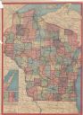
| Date: | 1913 |
|---|---|
| Description: | This map displays automobile routes across Wisconsin as well as Minnesota, Iowa, Michigan and Illinois. Cities, counties, Lake Michigan, Lake Superior, Gre... |
If you didn't find the material you searched for, our Library Reference Staff can help.
Call our reference desk at 608-264-6535 or email us at: