Filter: Categories of Wisconsin Historical Images
Filter: Subject of Water
Filter: Creator Name of Marr & Richards Engraving Co.
Filter: Categories of Wisconsin Historical Images
Filter: Subject of Water
Filter: Creator Name of Marr & Richards Engraving Co.

| Date: | 1885 |
|---|---|
| Description: | Mining and lumbering provided the impetus for the development of northern Wisconsin and Ashland was ideally situated to become a leading city of the "new W... |

| Date: | 1892 |
|---|---|
| Description: | Color bird's-eye map of Wauwatosa, looking east toward Milwaukee and Lake Michigan. Predominantly green with cream colored roadways, with six land plots ow... |

| Date: | 12 21 1882 |
|---|---|
| Description: | Bird's-eye map of Kaukauna, from the Appleton Post Annual Review. |

| Date: | 1881 |
|---|---|
| Description: | Bird's-eye view of Appleton. |

| Date: | 1890 |
|---|---|
| Description: | Colored bird's-eye map of Oconomowoc and the Lake Region, Waukesha County. Looking North from Government Hill. Location key below image identifies 24 Hotel... |

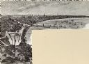
| Date: | 1886 |
|---|---|
| Description: | Bird's-eye view of Milwaukee from Bay View. |

| Date: | 1975 |
|---|---|
| Description: | Colored bird's-eye map of the Lake Region of Waukesha County. Looking North from Government Hill. All these Lakes and Resorts are withing Four hours ride o... |
If you didn't find the material you searched for, our Library Reference Staff can help.
Call our reference desk at 608-264-6535 or email us at: