| Date: | 1900 |
|---|---|
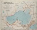
| Description: | Hydrographic map of Lake Mendota and it's adjacent topography. Prepared from surveys made by civil engineering students, University of Wisconsin, classes 1... |

| Date: | 1900 |
|---|---|
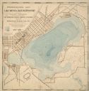
| Description: | A hydrographic map of Lake Monona and the adjacent topography. |

| Date: | 1898 |
|---|---|
| Description: | A hydrographic map of Lake Geneva that includes 15 cross sections of the depths at various points as well as a line running the length of the lake from Gen... |

| Date: | 1898 |
|---|---|
| Description: | This manuscript blueprint map covers property along Winnequah Road in area now part of Monona, Wisconsin. Lake Monona is labeled to the left and posts are ... |

| Date: | 12 1903 |
|---|---|
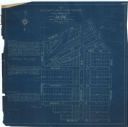
| Description: | This manuscript blueprint map shows streets and lots and includes certifications in the left margin. Horizontal streets top to bottom are: Iroquois, Main, ... |
If you didn't find the material you searched for, our Library Reference Staff can help.
Call our reference desk at 608-264-6535 or email us at: