 Filter: Categories of Wisconsin Historical Images
Filter: Subject of Water
Filter: Creator Name of Sturdevent
Filter: Categories of Wisconsin Historical Images
Filter: Subject of Water
Filter: Creator Name of Sturdevent
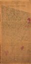
| Date: | 1872 |
|---|---|
| Description: | Shows what is currently Lincoln County and portions of Vilas, Oneida, Iron, and Langlade counties. Includes manuscript annotations of marked land tracts. |
If you didn't find the material you searched for, our Library Reference Staff can help.
Call our reference desk at 608-264-6535 or email us at: