 Filter: Categories of Wisconsin Historical Images
Filter: Subject of Water
Filter: Creator Name of Suydam, John V.
Filter: Categories of Wisconsin Historical Images
Filter: Subject of Water
Filter: Creator Name of Suydam, John V.
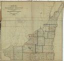
| Date: | 1837 |
|---|---|
| Description: | This map shows the townships, counties, prairies, and swamps in the Wisconsin Territory at the time. It includes the land south of the Wisconsin and Fox Ri... |

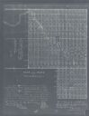
| Date: | 1836 |
|---|---|
| Description: | Map shows rivers, creeks, roads, trails, mills, and town of Madison. Includes significant manuscript annotations; Sheet 1 is watercolor on lithographed map... |

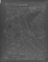
| Date: | 1836 |
|---|---|
| Description: | This map show plat of the city, local streets, block numbers, section lines, and canals. The map includes reference text: "Surveyor's office, Brown County ... |
| Date: | 1836 |
|---|---|
| Description: | This plat map shows the proposed Town of Whitesboro, a paper city (a city planned but never built), located on the Manitowoc River in Calumet County. Certi... |
| Date: | 1900 |
|---|---|
| Description: | This map shows a paper city located in section 23, township 17 north, range 22 east; area now occupied by the community of Spring Valley in Manitowoc Count... |
| Date: | 1900 |
|---|---|
| Description: | This map shows the paper city situated at the mouth of the Memee (Pigeon) River in Sheboygan County, just north of Sheboygan. Land parcels, streets, and ri... |

| Date: | 1900 |
|---|---|
| Description: | Map showing a paper city on the shore of Lake Apuckwa (Lake Puckaway) in Marquette or Green Lake County. The map includes certifications signed by John V. ... |

| Date: | 1900 |
|---|---|
| Description: | Map showing a paper city located on the shore of Green Bay and south shore of the Fox River. The site is now part of Oshkosh. |
If you didn't find the material you searched for, our Library Reference Staff can help.
Call our reference desk at 608-264-6535 or email us at: