 Filter: Categories of Wisconsin Historical Images
Filter: Subject of Water
Filter: Creator Name of Tirion, Isaak
Filter: Categories of Wisconsin Historical Images
Filter: Subject of Water
Filter: Creator Name of Tirion, Isaak
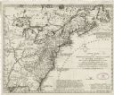
| Date: | 1755 |
|---|---|
| Description: | Dutch map of America and parts of Canada east of the Mississippi based largely on the famous John Mitchell map. It shows rivers, lakes, mountains, settlem... |

| Date: | 1769 |
|---|---|
| Description: | Map of New Orleans at the start of the French & Indian War, including two inset maps of the Mississippi River Delta and Fort la Balise. It shows streets, r... |
If you didn't find the material you searched for, our Library Reference Staff can help.
Call our reference desk at 608-264-6535 or email us at: