 Filter: Categories of Wisconsin Historical Images
Filter: Subject of Water
Filter: Creator Name of United States. Coast Survey.
Filter: Categories of Wisconsin Historical Images
Filter: Subject of Water
Filter: Creator Name of United States. Coast Survey.

| Date: | 1863 |
|---|---|
| Description: | This map illustrates the position of Fort Hindman at Arkansas Post on the Arkansas River. Depicted are the positions of Confederate defenses as well ships ... |
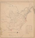
| Date: | |
|---|---|
| Description: | Map of the eastern United States that illustrates the limits of the "loyal states" as of July 1861 in red, the territory controlled by United States forces... |
If you didn't find the material you searched for, our Library Reference Staff can help.
Call our reference desk at 608-264-6535 or email us at: