 Filter: Categories of Wisconsin Historical Images
Filter: Subject of Water
Filter: Creator Name of University of Wisconsin--Eau Claire. Dept. of Geography.
Filter: Categories of Wisconsin Historical Images
Filter: Subject of Water
Filter: Creator Name of University of Wisconsin--Eau Claire. Dept. of Geography.

| Date: | 1969 |
|---|---|
| Description: | This Post Office Department map identifies post offices, summer post offices, rural stations, highway post offices, Post Office sectional centers, rural de... |
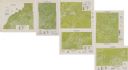
| Date: | 1975 |
|---|---|
| Description: | This series of six maps identifies land use in Taylor, Price, Rusk, Sawyer, Washburn, and Burnett counties based on data from 1966 through 1975. Each map i... |
If you didn't find the material you searched for, our Library Reference Staff can help.
Call our reference desk at 608-264-6535 or email us at: