 Filter: Categories of Wisconsin Historical Images
Filter: Subject of Water
Filter: County of Clark
Filter: Categories of Wisconsin Historical Images
Filter: Subject of Water
Filter: County of Clark

| Date: | 1880 |
|---|---|
| Description: | Bird's-eye map of Neillsville, with inset. |
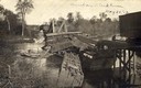
| Date: | 05 24 1912 |
|---|---|
| Description: | Wreck of a Minneapolis, St. Paul & Sault St. Marie Railroad train on a bridge over the Black River near Withee. The damage is so severe that the cars have ... |
| Date: | 1909 |
|---|---|
| Description: | The Soo line roundhouse. Caption reads: "Soo Round House, Abbottsford, Wis." |
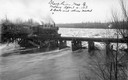
| Date: | 04 04 1913 |
|---|---|
| Description: | Elevated view of the Soo Line train crossing a bridge over the Black River near Withee. The three x's indicate places where the bridge had been damaged by ... |
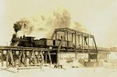
| Date: | |
|---|---|
| Description: | View from shoreline of the Fairchild & Northeastern steam locomotive pulling a load of logs over the Black River bridge near Greenwood. A man is standing o... |
| Date: | |
|---|---|
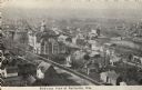
| Description: | Elevated view of town. Caption reads: "Bird's-eye View of Neillsville, Wis." |

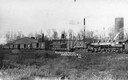
| Date: | 10 18 1937 |
|---|---|
| Description: | Elevated exterior view of the H.P. Ghent woodworking shop. A horse stands in the grass near a shoreline on the right, and a wagon parked near the shop bear... |
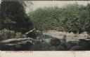
| Date: | 03 02 1908 |
|---|---|
| Description: | Colorized postcard of a river and tree-lined shore. Rocks are in the river and a bridge is in the background. Caption reads: "Riverside, Near Abbotsford, W... |
| Date: | 1924 |
|---|---|
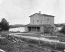
| Description: | The Humbird Roller Mill surrounded by rural landscape. A man leads on a porch beam as he poses for the picture. |
| Date: | 1873 |
|---|---|
| Description: | This 1873 map shows Clark County, Wisconsin, as well as the portion of Taylor County that was then part of Clark. The township and range grid, sections, ra... |

| Date: | 1880 |
|---|---|
| Description: | This 1880 map of Clark County, Wisconsin, shows the township and range grid, towns, sections, cities and villages, railroads, roads, rivers and lakes, dams... |
| Date: | 1914 |
|---|---|
| Description: | This early-20th century map of Clark County, Wisconsin, shows the township and range grid, towns, sections, cities and villages, property owners and acreag... |

| Date: | 1936 |
|---|---|
| Description: | This 1936 map of Clark County, Wisconsin, shows the township and range grid, sections, cities and town, and lakes and streams in the county. It lacks the k... |

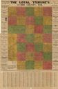
| Date: | 1933 |
|---|---|
| Description: | Blue line copy on paper with manuscript additions in color. Shows boundaries of zoned areas, Wisconsin historical lands in zoned areas, county lands outsid... |

| Date: | 1939 |
|---|---|
| Description: | Reservoir used to store water for raising cranberries. A large group of people are walking around the perimeter towards automobiles parked in the distance.... |
| Date: | 1910 |
|---|---|
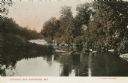
| Description: | Color postcard of the Eau Pleine River and trees along the river bank. Caption reads: "On Eau Pleine River, Colby, Wis." |

| Date: | 1910 |
|---|---|
| Description: | This set of manuscript blueprint maps show block and lot numbers, railroads, and some landownership, including lands and buildings of J.S. Owen Lumber Co. ... |
If you didn't find the material you searched for, our Library Reference Staff can help.
Call our reference desk at 608-264-6535 or email us at: