 Filter: Categories of Wisconsin Historical Images
Filter: Subject of Water
Filter: County of Forest
Filter: Categories of Wisconsin Historical Images
Filter: Subject of Water
Filter: County of Forest
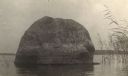
| Date: | 1905 |
|---|---|
| Description: | Rock near the principal village of the Chippewa Indian Reservation. |
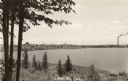
| Date: | 1942 |
|---|---|
| Description: | Elevated view from hill towards the city of Laona on the far shoreline. A large smokestack is spewing smoke. Caption reads: "Laona, Wis." |
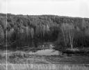
| Date: | 09 17 1961 |
|---|---|
| Description: | View down hill towards backwater area of the Wolf River, near it's source, surrounded by thick woods. Crop marks indicated by photographer. |

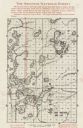
| Date: | 1920 |
|---|---|
| Description: | This 1920 map of Forest County, Wisconsin, shows the township and range grid, sections, cities and villages, lakes and streams, roads, "steam railroads," s... |

| Date: | 1919 |
|---|---|
| Description: | "Map no. 2, Keith and Hiles Lumber Co., Crandon, Wisconsin, Block Map, Block One... Made December 20, 1919. Maker of original map, B. McGinley. Maker of ta... |
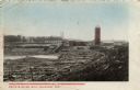
| Date: | 1910 |
|---|---|
| Description: | Colorized photographic postcard showing Keith & Hiles lumber mill. There is a tall building on the right that appears to be a silo. Caption reads: "Keith &... |

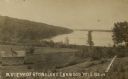
| Date: | 1920 |
|---|---|
| Description: | Colorized postcard view. Caption reads: "North Shore of Stone Lake. Planets (Near Crandon) Wis." Caption on back reads: "Looking towards the picturesque re... |
| Date: | 1910 |
|---|---|
| Description: | View looking down hill towards Stone Lake, with wooded shoreline and a two-story log building in the foreground. Caption reads: "A View of Stone Lake, Cran... |

| Date: | 1908 |
|---|---|
| Description: | Black & white photographic postcard showing wooded shoreline of Surprise Lake. There is a two-story house behind trees on the opposite shoreline. Caption r... |

| Date: | 1909 |
|---|---|
| Description: | Photographic postcard across water, showing launch owned by Schlitz Brewery of Milwaukee operating on Stone Lake. Caption reads: "Stone Lake, Crandon, Wis.... |
| Date: | 1905 |
|---|---|
| Description: | Photographic postcard view of Lake Metonga, with marshy area in foreground. Caption reads: "On Famous Lake Metonga, Crandon, Wis." |

| Date: | 1910 |
|---|---|
| Description: | Photographic postcard showing dirt road leading to the shoreline of Stone Lake near Crandon. Caption reads: "Approach to Stone Lake, Crandon, Wis." |

| Date: | 1960 |
|---|---|
| Description: | Chrome color postcard of the boat launch area. Text on back reads: "Forest County Veteran's Memorial Park located 3 miles from Crandon, WI on the south sho... |
| Date: | 1935 |
|---|---|
| Description: | This map shows land for sale by the company in northwestern part of Nicolet National Forest. The map also shows shoreline acreages, railroads, roads, trail... |

| Date: | 1972 |
|---|---|
| Description: | A topographic map of the Blackwell quadrangle. |

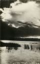
| Date: | 1961 |
|---|---|
| Description: | A narrow stream running under trees. The trees and banks are covered with fresh snow. |
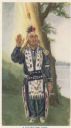
| Date: | 1920 |
|---|---|
| Description: | Full-length portrait of Potawatomi chief Simon Kahquados, born Kakanisaiga. He is depicted in his peace council attire. Caption reads: "A POTAWATOMI CHIEF.... |
If you didn't find the material you searched for, our Library Reference Staff can help.
Call our reference desk at 608-264-6535 or email us at: