 Filter: Categories of Wisconsin Historical Images
Filter: Subject of Water
Filter: County of Price
Filter: Categories of Wisconsin Historical Images
Filter: Subject of Water
Filter: County of Price
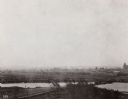
| Date: | 1894 |
|---|---|
| Description: | Elevated view of the town as it appeared following the fire of 1894. |
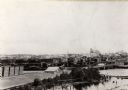
| Date: | 1890 |
|---|---|
| Description: | Elevated view of the town as it appeared before the fire of 1894. |
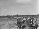
| Date: | 09 1934 |
|---|---|
| Description: | A large group of men working in a line with cranberry rakes to harvest cranberries in a flooded marsh. The men at work are all wearing waders. In the backg... |
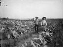
| Date: | 09 04 1895 |
|---|---|
| Description: | Men displaying produce, a large cabbage and a bushel of potatoes, while standing in the gardens of the Thayer farm. Cabbage, onion, currant, and raspberry ... |

| Date: | 1914 |
|---|---|
| Description: | This map of Price County, Wisconsin, from the early 20th century shows land for sale by the Homemaker Land Company of Milwaukee. The township and range sys... |

| Date: | 1925 |
|---|---|
| Description: | This map of Price County, Wisconsin, from the early 20th century shows the township and range system, towns, sections, cities and villages, railroads, high... |

| Date: | 1888 |
|---|---|
| Description: | This late 19th century map of Price County, Wisconsin, shows landownership and waterfront acreages, the township and range system, towns, cities and villag... |

| Date: | 1910 |
|---|---|
| Description: | This map from the early 20th century shows the Wisconsin Central Railroad land grant lands owned and for sale by the Soo Line in Price County, Wisconsin, a... |

| Date: | 1914 |
|---|---|
| Description: | This 1914 map of Price County, Wisconsin, shows land for sale by the Good Land Company and Dewitt van Ostrand of Phillips. Also shown are the township and ... |

| Date: | 1925 |
|---|---|
| Description: | This map of Price County, Wisconsin, from the early 20th century shows the township and range system, towns, sections, cities and villages, railroads, high... |

| Date: | 1986 |
|---|---|
| Description: | This late 1980s map of Price County, Wisconsin, shows facilities and lands open for public recreation, hunter walking trails and ski trails, campgrounds, b... |

| Date: | 1910 |
|---|---|
| Description: | This map is ink on paper. Shows Bruce’s proposed railway route and Moon’s railroad survey route along the Flambeau River, in parts of Lake and Eisenstein t... |
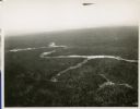
| Date: | 01 1934 |
|---|---|
| Description: | Aerial view of a forest with a river running through it. |

| Date: | 1903 |
|---|---|
| Description: | This blue line print map is oriented with the north to the left and shows buildings with dimensions, utilities, and proposed buildings. The Flambeau River ... |

| Date: | 11 1923 |
|---|---|
| Description: | This map shows buildings, lots, utilities, and original plat and present locations of railroads. Portions of the map are shown in red, brown, yellow, blue,... |

| Date: | 07 1937 |
|---|---|
| Description: | View across water towards a shoreline where men and boys are gathered on the bank of the Flambeau River, with several canoes and rowboats pulled up to the ... |
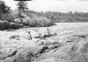
| Date: | 1935 |
|---|---|
| Description: | View from rocky shoreline towards three young men in a canoe running the Little Falls rapids on the South Fork of the Flambeau River. |
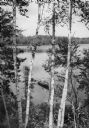
| Date: | 1950 |
|---|---|
| Description: | Elevated view of a man fishing in a rowboat seen through a stand of Birch trees on Miles Lake. |
If you didn't find the material you searched for, our Library Reference Staff can help.
Call our reference desk at 608-264-6535 or email us at: