Filter: Categories of Wisconsin Historical Images
Filter: Subject of Water
Filter: County of Waupaca
Filter: Categories of Wisconsin Historical Images
Filter: Subject of Water
Filter: County of Waupaca
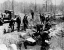
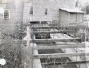
| Date: | 04 26 1936 |
|---|---|
| Description: | Planting trout in Waupaca County. Left to right on bank: S.A. LaVoilette, Joe Samz, Lloyd Pinkawski, Edwin Kargewski, W.M. Geiger, G. Moder, Billy LaVoilet... |

| Date: | 08 25 1912 |
|---|---|
| Description: | A band excursion on the sternwheel excursion, "Thistle." The sternwheel was previously named "J.H. Crawford." |
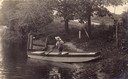
| Date: | |
|---|---|
| Description: | Laurie Peterson, son of the photographer, plays in boat. The photograph was originally titled "The Lone Boatsman". |
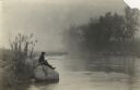
| Date: | |
|---|---|
| Description: | View across water towards Laurie Peterson, son of the photographer, fishing from a rock on a misty morning near the family home. |
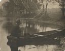
| Date: | |
|---|---|
| Description: | View from shoreline of the photographer, Carl A. Peterson, taking a moment to light his pipe while fishing from a boat near the family home. |
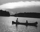
| Date: | 1945 |
|---|---|
| Description: | Couple canoeing under partly cloudy skies with sun dappling the water on Rainbow Lake, Chain O' Lakes. |

| Date: | 1871 |
|---|---|
| Description: | Birds eye map of New London depicts street names and street locations, houses, trees, the bridge, Wolf River, and the bayou. At the bottom of the map, a re... |

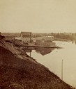
| Date: | 1965 |
|---|---|
| Description: | Aerial view of downtown Big Falls and the Little Wolf River. The Little Wolf River is at lower right. |
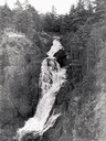
| Date: | 1940 |
|---|---|
| Description: | Big Manitou Falls with trees and observation area. |
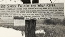
| Date: | 1920 |
|---|---|
| Description: | Sign for the toll road at Big Smoky Falls on the Wolf River. The sign reads: "Big Smoky Falls of the Wolf River. Many years ago before 1925 there was no ro... |
| Date: | 1940 |
|---|---|
| Description: | View of Taylor Lake and the entrance to Chain O' Lakes. |

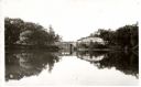
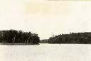
| Date: | 1910 |
|---|---|
| Description: | Aerial view of some of the 26 lakes known collectively as the Chain O' Lakes. Caption reads: "Aeroplane View of Chain O'Lakes, Waupaca, Wis." |
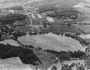
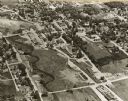
| Date: | 1965 |
|---|---|
| Description: | Aerial view looking west-northwest over Silver Lake. |
If you didn't find the material you searched for, our Library Reference Staff can help.
Call our reference desk at 608-264-6535 or email us at: