Filter: Categories of Wisconsin Historical Images
Filter: Subject of Water
Filter: Subject of human settlements
Filter: Categories of Wisconsin Historical Images
Filter: Subject of Water
Filter: Subject of human settlements
| Date: | |
|---|---|
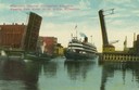
| Description: | Colorized view depicting the passenger excursion vessel, "Christopher Columbus," approaching the East Water Street Bridge. Caption reads: "Whaleback Steame... |
| Date: | 1863 |
|---|---|
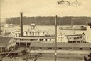
| Description: | Elevated view of the steamboat Golden Era, which did service during the Civil War, docked near buildings. It was sold to Michael Purcell of New Orle... |

| Date: | 1861 |
|---|---|
| Description: | Drawn the first year of the Civil War, this colored 1861 map of Dane County shows its towns, cities and lakes. It includes insets of the wards of Madison a... |
| Date: | 1900 |
|---|---|
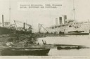
| Description: | The Superior Shipyards showing steamers "Moran", "Northwest" and "Northland. Caption reads: "Ship Yards — McDougall Whaleback. West Superior, Wis." |
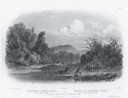
| Date: | 1832 |
|---|---|
| Description: | Engraving of Indians on horseback along river with Indian grave on hill in background. |

| Date: | |
|---|---|
| Description: | Men with shovels during the flood at Villa Louis. |

| Date: | 1891 |
|---|---|
| Description: | Bird's-eye map of Wausau, looking north with ninety-eight businesses, industries, churches, schools, and civic buildings identified in location key below i... |
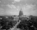
| Date: | 08 24 1945 |
|---|---|
| Description: | Elevated view of the Wisconsin State Capitol from the roof of the Loraine Hotel. |
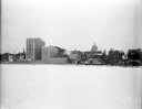
| Date: | 12 18 1955 |
|---|---|
| Description: | Downtown Madison lakeshore taken from Lake Monona in line with South Pinckney Street. Includes St. Raphael's steeple, 1 West Wilson Street state office bui... |

| Date: | 03 03 1957 |
|---|---|
| Description: | A view of Olin Terrace. The terrace and fountain were built in 1934 by CWA and FERA workers. It was designed by Frank Riley, Madison architect, in the Ital... |
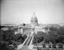
| Date: | 06 16 1928 |
|---|---|
| Description: | Elevated view of the Wisconsin State Capitol from the roof of the Loraine Hotel. In the background is Lake Mendota on the left, and on the right is Lake Mo... |
| Date: | 10 07 1930 |
|---|---|
| Description: | View of the Wisconsin State Capitol across Lake Monona from Olin Park. |

| Date: | 1886 |
|---|---|
| Description: | Bird's-eye view of Bayfield, county seat of Bayfield County. On the lower left side is an inset for Bayfield and the Apostle Islands. |

| Date: | 07 10 1949 |
|---|---|
| Description: | Aerial view of Minocqua showing the surrounding lakes. |

| Date: | 1780 |
|---|---|
| Description: | Hand-drawn plan for the layout of the town of Clarksville, bordering Mayfield Creek and Liberty Creek. Fort Jefferson is shown between the townsite and the... |

| Date: | 1853 |
|---|---|
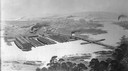
| Description: | Bird's-eye map of Milwaukee looking east toward Lake Michigan from a bluff, long since graded into a slope, at about 6th Street between Wisconsin Avenue an... |
| Date: | |
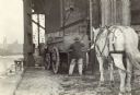
|---|---|
| Description: | Two men using a crane to unload wagon box on the waterfront. |
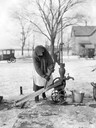
| Date: | 04 1923 |
|---|---|
| Description: | A bundled-up woman hand pumps water from a well into a pail. The ground is covered with ice and snow. Two cars and a farmhouse are in the background. |

| Date: | |
|---|---|
| Description: | Map of the district of the Peshtigo fire, approximately 1,280,000 acres, in Wisconsin and Upper Michigan. |
If you didn't find the material you searched for, our Library Reference Staff can help.
Call our reference desk at 608-264-6535 or email us at: