 Filter: Categories of Wisconsin Historical Images
Filter: Subject of Water
Filter: Subject of water
Filter: Subject of buses
Filter: Categories of Wisconsin Historical Images
Filter: Subject of Water
Filter: Subject of water
Filter: Subject of buses

| Date: | 06 01 1923 |
|---|---|
| Description: | Elevated view east from N. Plankinton Avenue, W. Wisconsin Avenue is bustling with automobiles, pedestrians, a cable car, and a double-decker bus. Landmark... |
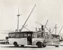
| Date: | 06 03 1925 |
|---|---|
| Description: | International "outer harbor" bus parked near a large boat and several harbor buildings. The bus was built on an International model 52 or model 53 chassis. |
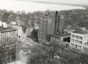
| Date: | 03 1954 |
|---|---|
| Description: | Elevated view looking north from the Wisconsin State Capitol down Hamilton Street. The Belmont Hotel and various storefronts are along Capitol Square. |
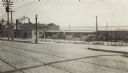
| Date: | 1918 |
|---|---|
| Description: | The East Madison Chicago, Milwaukee, and St. Paul railroad station, 501 East Wilson Street, from South Hancock Street, with Lake Monona in the background. ... |
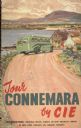
| Date: | 1930 |
|---|---|
| Description: | An original lithograph promoting Connemara, Ireland, and CIE Tours International travel company. Featuring the artist Costelloe, the poster depicts a bus t... |

| Date: | 10 31 1951 |
|---|---|
| Description: | Lineup of parade vehicles at Law Park along Lake Monona for Wisconsin's first civil defense support battalion test in Madison. |

| Date: | 1935 |
|---|---|
| Description: | Page in "International Trail" magazine displaying six photographs of International vehicles in use in Brazil. They are, clockwise from top left: Model C-50... |

| Date: | 1931 |
|---|---|
| Description: | This map is an advertisement for Milwaukee street cars and motor buses and reads: "Ride the street car or motor bus. Economical, safe, dependable." Include... |

| Date: | 1927 |
|---|---|
| Description: | Street railway and motor bus map with a legend of "Street Car Line," "Auxiliary Bus Lines," and "Motor Bus Lines." The routes are numbered. The map reads: ... |

| Date: | 1964 |
|---|---|
| Description: | Shows local streets, bus routes, highways, airport, Dells Pond, Half Moon Lake, Chippewa River, and Eau Claire River. Includes 2 inset maps: Location map a... |

| Date: | 1934 |
|---|---|
| Description: | This map includes a street index. The map is oriented with the north toward the upper right. Includes handwritten annotations of the 1935 bus routes. |

| Date: | 1976 |
|---|---|
| Description: | Indexed map of campus buildings, streets, and residence halls. Also included on the map is information about buses. The back of the map features campus bus... |

| Date: | 1994 |
|---|---|
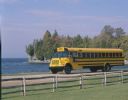
| Description: | Color photograph of an International 3600 Vista school bus on a gravel road along a shoreline. There is a man in the driver's seat. In the foreground is a ... |
| Date: | 1990 |
|---|---|
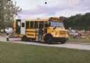
| Description: | Color photo of an International school bus driven along a coastal road. In the foreground is a split-rail fence and lawn. The photograph was probably taken... |
| Date: | 1993 |
|---|---|
| Description: | Color photo of a man and a woman assisting a girl on a wheelchair lift for a model 3600 Special Needs bus. The "International" emblem is on the front of th... |

| Date: | 1948 |
|---|---|
| Description: | This map of Milwaukee and surrounding suburbs includes an index to the orange bus, rapid transit, street car, trackless trolley, and the green bus lines. T... |

| Date: | 1936 |
|---|---|
| Description: | Street map of the City of Milwaukee and surrounding suburbs indicating various mass transit lines. There is an index to Milwaukee streets at the right of t... |

| Date: | 1927 |
|---|---|
| Description: | This map shows street car lines, bus routes, railroads, proposed city boundary lines, wards, public schools, blocks & house numbers, Lake Michigan, one mil... |

| Date: | 1927 |
|---|---|
| Description: | This map shows highways, roads, a proposed annexation, street car lines, bus routes, local motor bus lines, a new high speed interurban, railroads, a propo... |

| Date: | 1930 |
|---|---|
| Description: | This map shows streets, railways, bus lines, railroads, roads, parks, cemeteries, Lake Michigan, and a proposed harbor. Also included is a legend and on th... |
If you didn't find the material you searched for, our Library Reference Staff can help.
Call our reference desk at 608-264-6535 or email us at: