 Filter: Categories of Wisconsin Historical Images
Filter: Subject of Water
Filter: Subject of water
Filter: Subject of prisons
Filter: Categories of Wisconsin Historical Images
Filter: Subject of Water
Filter: Subject of water
Filter: Subject of prisons

| Date: | 1885 |
|---|---|
| Description: | Bird's-eye map of Waupun on the Rock River. There is an inset at top center of "Althouse, Wheeler & Co., Windmills and Pumps." |
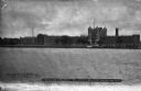
| Date: | 1921 |
|---|---|
| Description: | View across river toward the exterior of the prison, with the central tower and wings. A boat sits at the dock on the far shoreline, and a large smokestack... |
| Date: | |
|---|---|
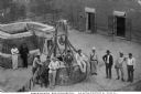
| Description: | Elevated view of prisoners posing by the washing well, in a courtyard. Some of the men wear hats. Wooden doors of a building are on the right. Caption read... |

| Date: | |
|---|---|
| Description: | Two views, one of a ferry and the other of a chain gang. The ferry operator poses with a man in his carriage on the ferry, with trees in the background. Th... |
| Date: | |
|---|---|
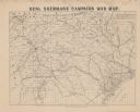
| Description: | Map covering most of Georgia and South Carolina, showing defenses along the seacoast and around the principal towns, Confederate prisons at Andersonville a... |

| Date: | 1937 |
|---|---|
| Description: | This Wisconsin Conservation Department map shows the locations of state forests, national forests, county forests, state nurseries, Indian reservations, st... |

| Date: | 1899 |
|---|---|
| Description: | This 1899 map of Dodge County, Wisconsin, shows the township and range grid, towns, sections, cities and villages, roads, railroads, post offices, cemeteri... |

| Date: | 1789 |
|---|---|
| Description: | Map of New York City showing ward boundaries, ferries, streets, roads, swamps, ponds, and rivers. The properties of Lispinard, Byards, Jones, Rutgers, and ... |
If you didn't find the material you searched for, our Library Reference Staff can help.
Call our reference desk at 608-264-6535 or email us at: