 Filter: Categories of Wisconsin Historical Images
Filter: Subject of Water
Filter: Subject of water
Filter: Subject of sioux indians
Filter: Categories of Wisconsin Historical Images
Filter: Subject of Water
Filter: Subject of water
Filter: Subject of sioux indians
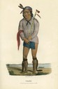
| Date: | 1835 |
|---|---|
| Description: | Waa-Na-'Taa or The Foremost in Battle, Chief of the Sioux Tribe. Hand-colored lithograph from the Aboriginal Portfolio, painted at the Treaty of Prairie du... |
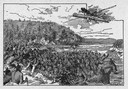
| Date: | 1845 |
|---|---|
| Description: | Illustration of Chippewa and Sioux Indians battling each other at the Brule River. Wood engraving from Armstrong, "Early Life Among The Indians." |
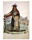
| Date: | 1835 |
|---|---|
| Description: | A Sioux Chief. Hand-colored lithograph from the Aboriginal Portfolio, painted at the Treaty of Prairie du Chien (1825). He holds a pipe. |
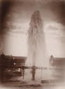
| Date: | |
|---|---|
| Description: | Water gushes 18 feet in the air from a 6-inch pipe at the Lower Brule Agency. A man stands behind the pipe on the right. |
| Date: | |
|---|---|
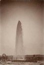
| Description: | Water gushes 60 feet in the air from a 4-inch pipe at the Lower Brule Agency. Two men stand on the left near pumping machinery. |

| Date: | 1837 |
|---|---|
| Description: | This map shows planned military posts/depots, barracks, rivers, lakes, roads, existing forts, and land assigned to various Indian tribes. Arkansas, Illinoi... |
| Date: | 1831 |
|---|---|
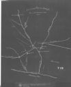
| Description: | This map was drawn by a Chippewa leader and shows the boundary lines between the Chippewa and Sioux territories and a saw-mill built by settlers without pe... |

| Date: | 1947 |
|---|---|
| Description: | This map shows the territories of Chippewa, Sioux, Winnebago, and Monomone tribes. It also shows navigation notes for rivers and lakes, Indian villages, hi... |

| Date: | 1705 |
|---|---|
| Description: | Map of America east of the Mississippi River showing boundaries, rivers, portages, forts, cities, villages, and Native American land. Annotations on early ... |
| Date: | 1884 |
|---|---|
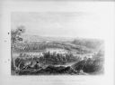
| Description: | Lithographic engraving depicting two people on a bluff overlooking a river. Several canoes are present on the river. Caption reads: "'Valley of the Minneso... |
If you didn't find the material you searched for, our Library Reference Staff can help.
Call our reference desk at 608-264-6535 or email us at: