Filter: Categories of Wisconsin Historical Images
Filter: Subject of Water
Filter: Subject of water
Filter: Year of 1700-1799
Filter: Categories of Wisconsin Historical Images
Filter: Subject of Water
Filter: Subject of water
Filter: Year of 1700-1799

| Date: | 1755 |
|---|---|
| Description: | Hand-colored. Paris: 1755. Scale [ca. 1:3,000,000]. |

| Date: | 1757 |
|---|---|
| Description: | The Canadian Lakes. Scale [ca. 1:6,500,000]. Paris: 1757. |
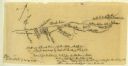
| Date: | 07 08 1774 |
|---|---|
| Description: | A hand-drawn map showing forts along the Clinch River. |

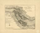
| Date: | 1778 |
|---|---|
| Description: | This Italian map from 1778 depicts the upper portion of the Old Northwest. Rivers and lakes are identified and relief, real and imagined, is depicted picto... |

| Date: | 1792 |
|---|---|
| Description: | Map of Washington D.C. Labeled on the map are all the main streets, the site of the Capitol and the President's House. The map also shows the relationship ... |

| Date: | 1774 |
|---|---|
| Description: | A hand-drawn plat map of Elkcorn (Elkhorn?) Creek. |

| Date: | 1720 |
|---|---|
| Description: | Double hemispherical world map showing routes of Tasman, Magellan, Mendana, etc. Relief shown pictorially. Title in oak wreath cartouche. Map between four ... |

| Date: | 1740 |
|---|---|
| Description: | From Weigel's Atlas portatilis, oder, Compendieuse Vorstellung der gantzen Welt. Map of Europe. |

| Date: | 1712 |
|---|---|
| Description: | Engraved double-hemispherical world map by Moll, included in his atlas The world described, or, A new and correct sett of maps: shewing the kingdoms and st... |

| Date: | 1798 |
|---|---|
| Description: | Engraved and hand-colored map of Egypt. Map title appears on bottom left as a carving in stone next ... |

| Date: | 1740 |
|---|---|
| Description: | Engraved and hand-colored map of the Iberian peninsula as a theater of war during the War of the Spanish Succession (1701-1714). The map is dedicated to Ki... |

| Date: | 1785 |
|---|---|
| Description: | Map of part of North America engraved and hand-colored (the light brown design is a superposition of the map and cartouche derived from the oxidation of th... |

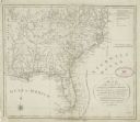
| Date: | 02 01 1793 |
|---|---|
| Description: | Text in the upper right corner reads, "A Map of The Western Part of the Territories belonging to the United States of America. Drawn from the best authorit... |

| Date: | 1760 |
|---|---|
| Description: | This map shows lakes, rivers, forts, settlements, and Native American tribal territory. The southern boundary of the Hudsons Bay Company is labeled. Relief... |
| Date: | 1792 |
|---|---|
| Description: | This map depicts the fixed boundaries by a peace treaty between the United States and the Spanish Dominions. |

| Date: | 1715 |
|---|---|
| Description: | A map of the countries and islands surrounding the Gulf of Mexico. The hand-colored borders separate the territories of England, France, Spain, and Holland... |

| Date: | 1721 |
|---|---|
| Description: | A map of North and South America with an elaborately illustrated cartouche depicting Native Americans in upper left corner. The map is fairly detailed, dep... |

| Date: | 1735 |
|---|---|
| Description: | A map of the western hemisphere, including parts of western Europe and Africa. Portraits of explorers, such as Jacques Marquette, Louis Joliet, and Robert ... |

| Date: | 1739 |
|---|---|
| Description: | This map shows the territorial claims of the western hemisphere by the European powers, as well as the names of major cities, geographical features, and pa... |
If you didn't find the material you searched for, our Library Reference Staff can help.
Call our reference desk at 608-264-6535 or email us at: