 Filter: Categories of Wisconsin Historical Images
Filter: Subject of Water
Filter: Subject of water
Filter: Year of 2000-Present
Filter: Community of Milwaukee
Filter: Categories of Wisconsin Historical Images
Filter: Subject of Water
Filter: Subject of water
Filter: Year of 2000-Present
Filter: Community of Milwaukee

| Date: | 11 16 2001 |
|---|---|
| Description: | Aerial view of General Mitchell International in Milwaukee, looking southeast to the Lake Michigan shoreline. |

| Date: | 2000 |
|---|---|
| Description: | This map shows the industrial area along the Menominee River and canals. Industrial buildings are shown in orange and labeled in red. Other areas are shown... |

| Date: | 2005 |
|---|---|
| Description: | This map shows dams and falls, areas of portage, canoe and kayak access, boat launches, parking, restrooms, picnic areas, dining, rapid water, parks, and b... |

| Date: | 11 08 2014 |
|---|---|
| Description: | Large slabs of rock line the shore of Lake Michigan. A tree is on the left. Heavy clouds are in the sky, with a patch of blue sky in the center. |
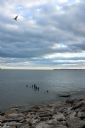
| Date: | 11 08 2014 |
|---|---|
| Description: | View looking down towards shoreline, with large slabs of rock in the foreground. There is a row of deteriorated pilings near the shoreline, with a bird per... |
If you didn't find the material you searched for, our Library Reference Staff can help.
Call our reference desk at 608-264-6535 or email us at: