Filter: Categories of Wisconsin Historical Images
Filter: Subject of Water
Filter: Year of 2000-Present
Filter: Year of 2000-2009
Filter: Categories of Wisconsin Historical Images
Filter: Subject of Water
Filter: Year of 2000-Present
Filter: Year of 2000-2009
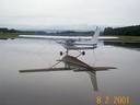
| Date: | 08 02 2001 |
|---|---|
| Description: | A rainy day at Middleton Municipal Airport, formerly the Morey Airfield. |

| Date: | 11 16 2001 |
|---|---|
| Description: | Aerial view of General Mitchell International in Milwaukee, looking southeast to the Lake Michigan shoreline. |

| Date: | 2007 |
|---|---|
| Description: | This map of Cedarbug is a bird's-eye map with 8 inset views and an index. The map is a print out of the original map dated 1892 held at the Cedarburg Cultu... |
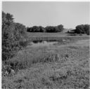
| Date: | 2001 |
|---|---|
| Description: | Landscape view of the pond at the Old Place on the Quinney farm. |

| Date: | 08 2008 |
|---|---|
| Description: | Elevated view of University Square shopping mall between West Johnson Street and University Avenue. (Demolished June 2006). Photograph taken from Witte Hal... |
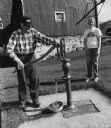
| Date: | 2004 |
|---|---|
| Description: | LeRoy Priesgen proves that this old pump still is capable of pumping water. |
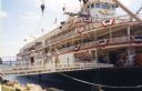
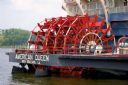
| Date: | 2004 |
|---|---|
| Description: | The "Delta Queen" steamboat at dock. People are walking across the gangplank toward the shoreline. |

| Date: | 07 2003 |
|---|---|
| Description: | Images of the American flag appear in tiny droplets of water. |

| Date: | 07 2003 |
|---|---|
| Description: | Water droplets capture the image of the American flag. |

| Date: | 07 2003 |
|---|---|
| Description: | This Barton dam is the subject of a photo study. Anna Williams acts as a model. |

| Date: | 07 2001 |
|---|---|
| Description: | David Obey poses with Park Ranger Geoffrey Smith on the left and Martin Hanson on the right. They are standing on the beach with water and land in the back... |
| Date: | 2000 |
|---|---|
| Description: | This map shows railroads by operating freight and government agencies, Amtrak stations, ports, rail lines out of service, rail banks, and Rails-to-Trails. ... |

| Date: | 2003 |
|---|---|
| Description: | The front of map shows trails throughout the bottom half of Wisconsin and includes text on snowmobile rules and tourism contacts. The reverse shows trails ... |

| Date: | 2008 |
|---|---|
| Description: | Underwater view of the stern of the schooner Home resting on the bottom of Lake Michigan. One of the masts is broken and is bending over the port si... |

| Date: | 06 12 2008 |
|---|---|
| Description: | Underwater view of the bow of the schooner Home. The port anchor is hanging along the port side of the ship. The bowsprit is laying on the lake bed ... |

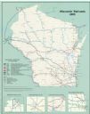
| Date: | 2000 |
|---|---|
| Description: | This map shows national parks, county and state forests, Indian reservations, municipal land, private land, docks, boat access, camping, and points of inte... |

| Date: | 06 12 2008 |
|---|---|
| Description: | Underwater view of the deck of the schooner Home, taken from the port side near the bow. The structure in the center of the deck is the centerboard ... |

| Date: | 09 28 2005 |
|---|---|
| Description: | Underwater view of the port anchor on the schooner Home. The anchor and chain are resting against the port side of the ship near the bow, partially ... |

| Date: | 09 09 2008 |
|---|---|
| Description: | Underwater view of a scuba diver (an underwater archaeologist) shining a light on two liquor or water jugs that had been pulled out during the archaeologic... |
If you didn't find the material you searched for, our Library Reference Staff can help.
Call our reference desk at 608-264-6535 or email us at: