 Filter: Categories of Wisconsin Historical Images
Filter: Subject of Water-supply
Filter: Subject of rivers
Filter: Categories of Wisconsin Historical Images
Filter: Subject of Water-supply
Filter: Subject of rivers
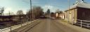
| Date: | 11 16 1989 |
|---|---|
| Description: | View from the Water Street Bridge over the Waupaca River toward the Waupaca Water Department. |

| Date: | |
|---|---|
| Description: | Exterior of Fairmount Water Works with numerous columned buildings overlooking a river with boats moored to a small dock. Another boat is on the river in m... |

| Date: | |
|---|---|
| Description: | Exterior photograph of the first water works in America, consisting of a stone cottage next to a stream. |

| Date: | 1947 |
|---|---|
| Description: | Lower left hand corner features a legend. "Drawn 1938, revised 1947." Shows water mains, hydrants, corporation limits, city ward divisions, fire proof buil... |

| Date: | |
|---|---|
| Description: | View across river or stream towards a pump house along a stony shoreline. A large pipe supported on trestles is attached to the right side of the building.... |

| Date: | 1892 |
|---|---|
| Description: | This map shows water pipes, hydrants, stop cocks, check valves, fire cysterns, and manholes. Also shown are block numbers, streets, railroads, parks, cemet... |

| Date: | 04 1901 |
|---|---|
| Description: | A Sanborn map of Watertown, including an index and a key. |
If you didn't find the material you searched for, our Library Reference Staff can help.
Call our reference desk at 608-264-6535 or email us at: