 Filter: Categories of Wisconsin Historical Images
Filter: Subject of Waterfalls
Filter: Creator Name of Unknown
Filter: Categories of Wisconsin Historical Images
Filter: Subject of Waterfalls
Filter: Creator Name of Unknown
| Date: | |
|---|---|
| Description: | Elevated view of a river, and Fergus Falls buildings in the background. Buildings lining the river have signs that read: "E.T. Bernard," "Hardware," and "S... |

| Date: | |
|---|---|
| Description: | View of the Lower Falls on the Spokane River. A building on the left has a sign that reads: "Washington Water Power Company." |

| Date: | |
|---|---|
| Description: | View of a landscape with a rocky stream in foreground and town set in countryside in the distance. Shelburn Falls can be seen among industrial and resident... |
| Date: | |
|---|---|
| Description: | View of Milford City Hall, built in 1916. A waterfall is visible in the foreground. |
| Date: | 09 25 1922 |
|---|---|
| Description: | The reservoir bulkhead and watershed for the Edward Hableman cranberry marshes. The reservoir was part of the irrigation system used to flood the cranberry... |

| Date: | |
|---|---|
| Description: | Passengers aboard a cable car prepare for their trip over Niagara Falls. |

| Date: | |
|---|---|
| Description: | Passengers aboard a cable car begin their trip across Niagara Falls. |

| Date: | |
|---|---|
| Description: | Distant view of passengers aboard a cable car traveling over Niagara Falls. |
| Date: | |
|---|---|
| Description: | Letterhead of the Wisconsin Bank Note and Lithographing Company of Milwaukee, Wisconsin, with a child writing on a tablet and perching on a banner bearing ... |

| Date: | 1941 |
|---|---|
| Description: | A tourist map of Marinette County, Wisconsin that includes indexes of the lakes and rivers in the county which also identify the fish present, a list of ra... |

| Date: | 01 09 1849 |
|---|---|
| Description: | Shows county line boundaries, rivers, and falls. Includes explanation of township and county divisions. Pen and pencil on paper. Title supplied by cataloge... |
| Date: | |
|---|---|
| Description: | Photographic postcard view of a trout stream with rapids and trees on the shoreline. Caption reads: "Trout Steam, Fallhall Glen on Trail 27, 7 Miles South ... |
| Date: | 1931 |
|---|---|
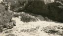
| Description: | A group of people stand on a ledge overlooking Copper Falls. |

| Date: | 1698 |
|---|---|
| Description: | An illustration of two men looking out at Niagara Falls. The Niagara Falls in Jean Louis Hennepin’s A new discovery of a vast country in America (London: M... |
| Date: | |
|---|---|
| Description: | View of cars parked in the parking lot at Pattison State Park, near the entry gate and sign, which reads: "Pattison State Park, Manitou Falls — Height 165 ... |

| Date: | 1900 |
|---|---|
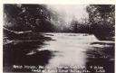
| Description: | Photographic postcard view up the Wisconsin River near the foot of Grandfather Falls, which falls 90 feet in 1 1/2 miles. Caption reads: "Near the foot of ... |

| Date: | |
|---|---|
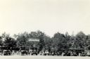
| Description: | Group portrait of people picnicking on the shoreline of a river. In the background is an unidentified waterfall, with tree limbs and branches stuck in the ... |

| Date: | |
|---|---|
| Description: | Photographic postcard of Smoky Falls, now called Big Smokey Falls and found within the Menominee Nation. A boy is standing on the left near the falls. |
| Date: | 1910 |
|---|---|
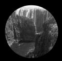
| Description: | Elevated view looking over the Zambesi River towards Victoria Falls, South Africa. |

| Date: | 1910 |
|---|---|
| Description: | View of Victoria Falls, South Africa, looking East. |
If you didn't find the material you searched for, our Library Reference Staff can help.
Call our reference desk at 608-264-6535 or email us at: