 Filter: Categories of Wisconsin Historical Images
Filter: Subject of Waterfalls
Filter: Creator Name of Unknown
Filter: Categories of Wisconsin Historical Images
Filter: Subject of Waterfalls
Filter: Creator Name of Unknown

| Date: | 1780 |
|---|---|
| Description: | Map of eastern Massachusetts, Rhode Island, eastern Connecticut, and small portions of New Hampshire and Vermont. It shows the boundaries, counties, citie... |

| Date: | 1755 |
|---|---|
| Description: | Map of the Great Lakes region during the French and Indian War. It shows in great detail the territories, borders and boundary lines, Native American tribe... |
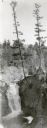
| Date: | 1930 |
|---|---|
| Description: | An elevated view of Brownstone Falls. Two tall pines are growing at the top edge of a rock to the right of the falls. |

| Date: | |
|---|---|
| Description: | View across Como Falls. Bluffs are in the background on the right. |
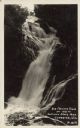
| Date: | 08 07 1942 |
|---|---|
| Description: | Text on front reads: "Big Manitou Falls, Ht. 165 Ft., Pattison State Park, Superior, Wis." The falls are on the Black River and surrounded by shrubs and ro... |
If you didn't find the material you searched for, our Library Reference Staff can help.
Call our reference desk at 608-264-6535 or email us at:
