 Filter: Categories of Wisconsin Historical Images
Filter: Subject of Weather
Filter: Year of 1800-1899
Filter: Year of 1860-1869
Filter: Categories of Wisconsin Historical Images
Filter: Subject of Weather
Filter: Year of 1800-1899
Filter: Year of 1860-1869
| Date: | 1866 |
|---|---|
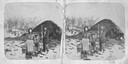
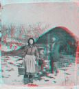
| Description: | Stereograph of woman, man and child outdoors on a farm with snow on the ground. The woman is wearing bloomers and is holding a bucket in the process of doi... |
| Date: | 1861 |
|---|---|
| Description: | Soldiers in formation at Camp Randall during winter. The season [there appears to be snow on the ground] and the tents indicate that this image was made in... |
| Date: | 1860 |
|---|---|
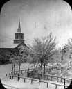
| Description: | Elevated wintertime view of the intersection of South Carroll and West Main Streets, showing the First Baptist Church constructed in 1854, the wooden fence... |
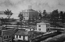
| Date: | 1868 |
|---|---|
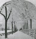
| Description: | Winter scene with the snow-covered pathway and trees around the Capitol Park. A wooden fence ran along the inside of the path and a hitching rail for hors... |
| Date: | 1860 |
|---|---|
| Description: | Elevated illustration of the Lawrence College Campus with snow on the ground. |
| Date: | 1865 |
|---|---|
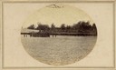
| Description: | Elevated view of the fort, with snow on the ground. |

| Date: | 1865 |
|---|---|
| Description: | Map showing the location of meteorological stations and effects that Lake Michigan has had on Wisconsin temperatures in January and July. The map shows cou... |
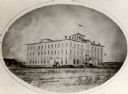
| Date: | 1864 |
|---|---|
| Description: | Oval-framed view of Lawler Hall at Campion College. This image was made during the Civil War when the building was used as a U.S. Military hospital. Prior ... |
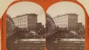
| Date: | 1869 |
|---|---|
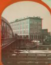
| Description: | Stereograph of the Axtell House building, with a storefront next to it advertising "Clothing Hats Caps Sailors Outfits". A bridge is on the left and a man... |
| Date: | 1866 |
|---|---|
| Description: | Stereograph of woman, man and child outdoors on a farm with snow on the ground. The woman is wearing bloomers and is holding a bucket in the process of doi... |
| Date: | 1869 |
|---|---|
| Description: | Stereograph of the Axtell House building, with a storefront next to it advertising "Clothing Hats Caps Sailors Outfits". A bridge is on the left and a man... |

| Date: | 1866 |
|---|---|
| Description: | This thematic shows the effects that Lake Michigan has had on Wisconsin mean temperatures in January and July. The map shows counties, some cities, rivers ... |

| Date: | 1865 |
|---|---|
| Description: | Drawn the last year of the Civil War, this thematic map shows the effects that Lake Michigan has had on Wisconsin temperatures in January and July. The map... |
| Date: | 02 20 1869 |
|---|---|
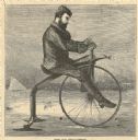
| Description: | Engraved image of a man riding an ice velocipede, a bicycle-like vehicle with a studded front wheel and back blades. In the background is an iceboat. |

| Date: | 1868 |
|---|---|
| Description: | This map of the state of Wisconsin was created in 1868 and later used by Increase Lapham to trace an outbreak of tornadoes going across the state in May of... |

| Date: | 1868 |
|---|---|
| Description: | This map is one of the earliest weather maps of the United States, which traced an 1859 storm across the continent. Manuscript annotations in red ink show ... |

| Date: | 1862 |
|---|---|
| Description: | This map shows the population by county, the basic geology, climate, and the distribution of timber within the state of Wisconsin. It shows mean seasonal t... |
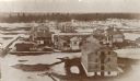
| Date: | 1867 |
|---|---|
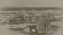
| Description: | Elevated view of Fort Howard, from the top of a grain elevator, when it was being destroyed to make room for the Chicago and Northwestern Railway switchyar... |
If you didn't find the material you searched for, our Library Reference Staff can help.
Call our reference desk at 608-264-6535 or email us at: