 Filter: Categories of Wisconsin Historical Images
Filter: Subject of Winter sports
Filter: Subject of parks
Filter: Categories of Wisconsin Historical Images
Filter: Subject of Winter sports
Filter: Subject of parks
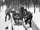
| Date: | 09 13 1949 |
|---|---|
| Description: | Winter scene with Lawrence College students tobogganing at Rib Mountain near Wausau. |
| Date: | 01 02 1988 |
|---|---|
| Description: | Bundled-up boys ride their tubes down an icy slope in Mee-Kwon Park. |
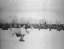
| Date: | 02 19 1940 |
|---|---|
| Description: | A couple, most likely Gerda Wank with Joe Puccetti, in the middle of an ice skating exhibition. A crowd of children and adults is watching from a snowbank ... |
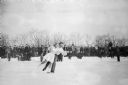
| Date: | 02 11 1941 |
|---|---|
| Description: | A couple, most likely Gerda Wank with Joe Puccetti, in the middle of an ice skating exhibition. The man is holding the woman almost parallel to the ice whi... |

| Date: | 01 29 1950 |
|---|---|
| Description: | Group portrait of the title winners in the all-city skating championships at Vilas Park. Shown on the ice are, from left to right: (front row) John Glidde... |

| Date: | |
|---|---|
| Description: | View of people playing winter sports (sking and skating) at Virginia Kendall Park, a large, snow-covered area with a dwelling in the background. |

| Date: | 1959 |
|---|---|
| Description: | This map of Lake Geneva has relief shown by contours and water depths shown by isolines. The map includes an index of schools, churches, public services, i... |

| Date: | 01 22 1961 |
|---|---|
| Description: | Group portrait of 23 young ice skaters who all won championships in the 1961 city speed skating meet at Vilas Park. |
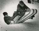
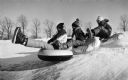
| Date: | 12 23 1970 |
|---|---|
| Description: | Winter scene with teenage toboggan riders, Rick Borckel (age 14) and Pat Voight (age 13), hitting a bump on a hill in Brown Deer Park, Milwaukee. |

| Date: | 1966 |
|---|---|
| Description: | This colored road map shows automobile roads in Wisconsin as well as portions of nearby states. A map key indicates relative sizes of cities and towns. On ... |

| Date: | 1970 |
|---|---|
| Description: | This colored map displays a brief description of tourist attractions in the state, as well as a grid of state parks and recreational facilities. There is a... |

| Date: | 1966 |
|---|---|
| Description: | This colored road map shows automobile roads in Wisconsin as well as portions of nearby states. Information on the quality and type of any road shown (inte... |

| Date: | 1970 |
|---|---|
| Description: | This colored map displays detailed maps of Green Bay, Appleton, Racine, Milwaukee, Kenosha, and Duluth-Superior. At the top right is a map location list of... |

| Date: | 1971 |
|---|---|
| Description: | This colored map displays Wisconsin and bordering areas of Iowa, Minnesota, and Michigan. There is color-coding on the map to indicate National Forests, an... |

| Date: | 1973 |
|---|---|
| Description: | This colored map displays Wisconsin and bordering areas of Iowa, Minnesota, and Michigan. There is color-coding on the map to indicate National Forests, a... |

| Date: | 1975 |
|---|---|
| Description: | This colored road map of Wisconsin displays "Featured Points of Interest" and "Historical Points of Interest" in the state, including three color photograp... |

| Date: | 1973 |
|---|---|
| Description: | This map displays, in color, Wisconsin and bordering areas of Iowa, Minnesota, Illinois, and Michigan. At the bottom is a map key indicating road classifi... |

| Date: | 1976 |
|---|---|
| Description: | This color map displays Wisconsin and bordering areas of Iowa, Minnesota, Illinois, and Michigan. At the bottom is a map key indicating road classification... |

| Date: | 1976 |
|---|---|
| Description: | This colored map displays Wisconsin and portions of bordering states, including a detailed map of the Wisconsin Dells area. Surrounding the map are multipl... |

| Date: | 1977 |
|---|---|
| Description: | This colored map displays Wisconsin and portions of bordering states, including a detailed map of the Wisconsin Dells area. Surrounding the map are multipl... |
If you didn't find the material you searched for, our Library Reference Staff can help.
Call our reference desk at 608-264-6535 or email us at: